
College Hill, Wichita, Kansas
College Hill | |
|---|---|
 The Aviary, 330 Circle Drive | |
| Country | United States |
| State | Kansas |
| County | Sedgwick |
| City | Wichita |
| Elevation | 1,360 ft (410 m) |
| ZIP code | 67208, 67211, 67214, 67218 |
| Area code | 316 |
College Hill is a historic, predominantly residential neighborhood in Wichita, Kansas, United States.[1]
History
College Hill was platted as a series of developments during a real estate speculation boom of the 1880s. The name came from a proposed Methodist college that would have been located in the neighborhood at Douglas and Rutan, but the Methodist church instead choose to build its college, today known as Southwestern College, in Winfield, Kansas. While a few houses in the neighborhood were built prior to the turn of the century, most were built between 1900 and 1934. In December 1926, the Lincoln Heights Addition between Douglas and Kellogg and Oliver and Crestway consisting of 73 acres and 250 lots was placed on the market. Construction of Lincoln Heights Shopping Center at Douglas and Oliver, begun in June 1948, was completed in July 1949. [2]
The area that is now College Hill Park served as the Wichita Country Club from 1901-1912. It was redeveloped from an overgrown golf course into its current park configuration, including its swimming pool, via WPA funds during the Great Depression.[3]
Geography
College Hill is located at 37°41′13″N 97°17′22″W / 37.68694°N 97.28944°W (37.686944, -97.289444) at an elevation of 1,360 feet (410 m).[4] It comprises the area between Central Avenue to the north and U.S. Route 54 to the south and between Hillside Street to the west and Oliver Avenue to the east.[1][5] Located approximately 2.5 miles (4 km) east of Downtown Wichita, College Hill borders the neighborhoods of Sleepy Hollow and Country Overlook to the north, Crown Heights North and Crown Heights South to the east, Fairfax and Longview to the south, and East Front and Uptown to the west.[1]
Government
For the purposes of representation on the Wichita City Council, College Hill lies within Council District 1.[6]
For the purposes of representation in the Kansas Legislature, College Hill is located in the 29th district of the Kansas Senate and the 84th district of the Kansas House of Representatives.[7]
Parks and recreation

- College Hill Park (including pool and two tennis courts)
Culture
Points of interest
- Allen-Lambe House
- Crown Uptown Theatre
- Lincoln Heights Shopping Center
Gallery
-
 The Allen-Lambe House (2013)
 -
 The C. M. Jackman House (2013)
 -
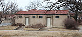 The College Hill Park Bathhouse (2013)
 -
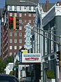 The Crown Uptown Theatre with the Hillcrest Apartments in the background (2003)


References
- ^ a b c "Neighborhood Associations - City of Wichita, Kansas" (PDF). City of Wichita. 2012-06-13. Retrieved 2012-10-27.
- ^ Tihen, Edward. "Tihen Notes, Wichita Eagle, Wichita State University Libraries' Department of Special Collections, 1926 through 1949" (PDF).
- ^ White, Rebecca. "College Hill history part of Wichita's struggle for national status". KWCH. Retrieved 2014-06-26.
- ^ College Hill, Wichita, KS, Google Earth, 2012-10-27
- ^ "College Hill, Wichita, KS". Google Maps. Retrieved 2012-10-27.
- ^ "Council Districts [map]" (PDF). City of Wichita. Archived from the original (PDF) on 2014-03-30. Retrieved 2014-07-07.
{{cite web}}: Unknown parameter|deadurl=ignored (|url-status=suggested) (help) - ^ "Kansas Data - 2012 Primary Election Districts". University of Kansas Institute for Policy & Social Research. Archived from the original on 2012-08-08. Retrieved 2012-10-27.
{{cite web}}: Unknown parameter|deadurl=ignored (|url-status=suggested) (help)
| General | |
|---|---|
| Neighborhoods | |
| Landmarks and culture | |
| Museums | |
| Event venues | |
| Colleges and universities | |