Coria, Cáceres
Coria | |
|---|---|
Municipality | |
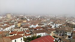
 View of Coria | |
| Coordinates: 39°58′55″N 6°32′14″W / 39.98194°N 6.53722°W | |
| Country | Spain |
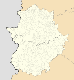
| Autonomous community | Extremadura |
| Province | Cáceres |
| Government | |
| • Mayor | José Manuel García Ballester (PP) |
| Area | |
| • Total | 103.46 km2 (39.95 sq mi) |
| Elevation | 280 m (920 ft) |
| Population (2018)[1] | |
| • Total | 12,531 |
| • Density | 120/km2 (310/sq mi) |
| Demonym | Caurienses or Corianos |
| Time zone | UTC+1 (CET) |
| • Summer (DST) | UTC+2 (CEST) |
| Website | Official website |
Coria (Spanish: [ˈkoɾja] ) is a municipality of Spain belonging to the province of Cáceres, Extremadura. In addition to the town of the same name, the municipality also comprises the settlements of Puebla de Argeme and Rincón del Obispo. With a population of has 12,531 inhabitants, Coria is the fourth most-populated municipality in the province.
It is located on the Alagón river bank.
Coria preserves several monuments and holds an annual national tourist interest festival in honor of San Juan.
History
[edit]Founded before the Romans occupied the Iberian Peninsula, and called Caura, the Romans gave it its present name in Latin, Caurium, and later the city was granted Roman citizenship. Later under the Visigoths, the Diocese of Coria was created. The centuries in which Coria was the only capital of the diocese were of great prosperity for the city.
Ordoño I of Asturias raided Coria and its surroundings circa 859−860, returning to the north with a loot that included the local Christian Mozarab population.[2]
During the time that Muslim Coria was a borderland city, it had probably an average demographic importance, offset by a larger geostrategic notability,[3] located in between the Tagus and the Sistema Central. Arabic sources hint towards a larger importance of agrarian activities rather than livestock.[3] Christian sources suggest the existence of a scattered mode of population with the probable proliferation of alquerías around the medina.[3]
Coria was conquered by Christians in 1077, and held briefly.[4] It was conquered by the Almoravids just after 1109 and unsuccessfully besieged in 1138. A successful Christian conquest followed after a two-month siege in 1142, after which the diocese was restored.[5] In 1174, the place was taken over by the troops of Almohad general Abu Hafs, returning to Christian rule after 1184.[5] While it is understood the place should have already enjoyed its own fuero by the early 13th-century, the first evidence about the existence of a local fuero (presumably modelled after the second fuero of Ciudad Rodrigo) traces back to 1227.[6]
Coria became the capital of a lordship to which some towns are still named after, such as Guijo de Coria or Casillas de Coria.
During the 1640−1668 War against Portugal, the land of Coria suffered greatly; although the city was not taken by the Portuguese, the countryside was reiterately raided, causing the impoverishment of the region.[7]
Climate
[edit]Coria has a hot summer mediterranean climate (Csa in Köppen climate classification), with mild wet winters and very hot, dry summers.[8] During the summer temperatures often exceed 35 °C (95 °F) and can reach over 40 °C (104 °F) during heat waves. During winter, temperatures below 0 °C (32 °F) are rare, but can occur during the coldest nights of the year. Precipitation is concentrated in the autumn and winter months.
| Climate data for Coria 1991-2020 normals | |||||||||||||
|---|---|---|---|---|---|---|---|---|---|---|---|---|---|
| Month | Jan | Feb | Mar | Apr | May | Jun | Jul | Aug | Sep | Oct | Nov | Dec | Year |
| Mean daily maximum °C (°F) | 12.3 (54.1) |
14.4 (57.9) |
18.0 (64.4) |
20.5 (68.9) |
25.4 (77.7) |
30.9 (87.6) |
35.1 (95.2) |
34.9 (94.8) |
29.8 (85.6) |
22.6 (72.7) |
16.0 (60.8) |
12.6 (54.7) |
22.7 (72.9) |
| Daily mean °C (°F) | 7.7 (45.9) |
9.2 (48.6) |
12.3 (54.1) |
14.6 (58.3) |
18.8 (65.8) |
23.6 (74.5) |
27.0 (80.6) |
26.9 (80.4) |
22.8 (73.0) |
17.1 (62.8) |
11.6 (52.9) |
8.5 (47.3) |
16.7 (62.0) |
| Mean daily minimum °C (°F) | 3.1 (37.6) |
4.0 (39.2) |
6.5 (43.7) |
8.6 (47.5) |
12.1 (53.8) |
16.2 (61.2) |
18.9 (66.0) |
18.9 (66.0) |
15.7 (60.3) |
11.7 (53.1) |
7.0 (44.6) |
4.3 (39.7) |
10.6 (51.1) |
| Average rainfall mm (inches) | 45.3 (1.78) |
44.2 (1.74) |
56.4 (2.22) |
47.2 (1.86) |
33.8 (1.33) |
8.4 (0.33) |
3.0 (0.12) |
5.4 (0.21) |
25.6 (1.01) |
82.6 (3.25) |
72.2 (2.84) |
69.0 (2.72) |
493.1 (19.41) |
| Source: Agencia Estatal de Meteorologia (AEMET OpenData)[9] | |||||||||||||
Sights
[edit]- Roman walls (3rd-4th centuries AD)
- Cathedral of Santa María de la Asunción, in transitional Gothic style
- Bishop's palace (1628)
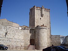
- Castle of Coria (1472–1478)
- Baroque Hermitage of Nuestra Señora de Argeme (17th century)
- Royal Prisons (1686)
- Old Bridge (Puente Viejo), dating to the 15th-16th centuries
- Convent of the Madre de Dios, founded in the 13th century. The current structure dates to the 14th-16th centuries
- Church of Santiago, in Baroque style (16th-18th centuries)
- Palaces of the Dukes of Alba (15th-16th centuries)
 |
 |
 |
 |
See also
[edit]References
[edit]- ^ Municipal Register of Spain 2018. National Statistics Institute.
- ^ Casillas Antúnez, Francisco José (2008). "Historia y toponimia de la tierra de Coria" (PDF). Alcántara (68): 33.
- ^ a b c Clemente Ramos & Montaña Conchiña 1994, p. 89.
- ^ Clemente Ramos, Julián; Montaña Conchiña, Juan Luis de la (1994). "La Extremadura cristiana (1142-1230): ocupación del espacio y transformaciones socioeconómicas". Historia. Instituciones. Documentos (21). Salamanca: University of Salamanca: 88. doi:10.12795/hid.1994.i21.05.
- ^ a b Meyer-Hermann 2016, pp. 140.
- ^ Meyer-Hermann, Reinhard (2016). "Acerca de la relación (genealógica) entre los Fueros de Coria y de Castelo Bom". Lusíada. Direito (15): 140–141. ISSN 2182-4118.
- ^ Casillas Antúnez 2008, p. 40.
- ^ Meteorología, Agencia Estatal de. "Valores climatológicos normales - Agencia Estatal de Meteorología - AEMET. Gobierno de España". www.aemet.es (in Spanish). Retrieved 2024-05-05.
- ^ "AEMET OpenData". Retrieved 4 May 2024.


