Cumbria Coastal Way
Appearance
| Cumbria Coastal Way | |
|---|---|
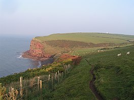
 St. Bees Head which lies on the trail | |
| Length | 298 km (185 mi) |
| Location | Northern England, United Kingdom |
| Trailheads | Silverdale, Lancashire Gretna, Dumfries and Galloway |
| Use | Hiking |
| Season | All year |

The Cumbria Coastal Way (CCW) is a long-distance footpath in Cumbria in northern England, following the coast from Silverdale, just over the Lancashire border, to just north of the Anglo-Scottish border. It is now part of the England Coast Path.
The Long Distance Walkers Association reports, as of 2022[update], that "The route is no longer marked on OS maps and is not endorsed by Cumbria County Council; some permissive paths no longer have access rights so diversions are necessary in places."[1]
The path follows some interesting scenery such as the red sandstone cliffs of St. Bees Head. It passes through the following locations (from South to North):
- Silverdale, Lancashire - 54°10′01″N 2°49′37″W / 54.167°N 2.827°W
- Arnside
- Grange-over-Sands
- Greenodd
- Ulverston
- Barrow-in-Furness
- Askam-in-Furness
- Kirkby-in-Furness
- Broughton-in-Furness
- Millom
- Ravenglass
- Seascale
- St. Bees
- St. Bees Head
- Whitehaven
- Workington
- Maryport
- Allonby
- Mawbray
- Beckfoot
- Silloth
- Abbeytown
- Burgh by Sands
- Carlisle - 54°53′42″N 2°56′02″W / 54.895°N 2.934°W
References
[edit]- ^ "Cumbria Coastal Way". www.ldwa.org.uk. Long Distance Walkers Association. Retrieved 23 April 2022.
- Brodie, Ian O.; Brodie, Krysia (1994). The Cumbria Coastal Way. Ellenbank Press. ISBN 1-873551-10-X.
- Brodie, Ian O.; Brodie, Krysia (2007). The Cumbria Coastal Way. Milnthorpe: Cicerone. ISBN 978-1-85284-430-1.
External links
[edit]Wikimedia Commons has media related to Cumbria Coastal Way.
