
Cypress Street Viaduct: Difference between revisions
BOT--Reverting link addition(s) by Derek20la to revision 300465350 (http://www.youtube.com/watch?v=lmnxziw3hjk) |
i feel the video is important because you can see the flaws in construction which would lead to its failure during the 1989 earthquake.if there is a more appropriate way to add this link,please modify |
||
| Line 99: | Line 99: | ||
== External links == |
== External links == |
||
* [http://www.imdb.com/title/tt0107578/ ''Miracle on Interstate 880''] (1993), TV movie fictionalization and re-enactment of events at the Cypress Structure. |
* [http://www.imdb.com/title/tt0107578/ ''Miracle on Interstate 880''] (1993), TV movie fictionalization and re-enactment of events at the Cypress Structure. |
||
* [http://www.youtube.com/watch?v=lMnXZiw3hJk ''Construction of the Cypress Viaduct (part 1 of 5)''] (1950s), Caltrans video showing the progress of construction and engineering methods used. |
|||
{{coord|37.8168|-122.2895|region:US_type:landmark|display=title}} |
{{coord|37.8168|-122.2895|region:US_type:landmark|display=title}} |
||
Revision as of 00:25, 6 July 2009
Cypress Street Viaduct | |
|---|---|
| Cypress Freeway, Nimitz Freeway | |
| Route information | |
| Maintained by Caltrans | |
| Length | 1.78 mi (2.86 km) |
| Existed | 1957 as |
| NHS | Entire route |
| Major junctions | |
| North end | |
| South end | Market Street at 7th Street in Oakland |
| Location | |
| Country | United States |
| State | California |
| Highway system | |

.svg)
The Cypress Street Viaduct was a 2-kilometer long, raised two-tier, multi-lane (four lanes per deck) freeway constructed of reinforced concrete that was originally part of the Nimitz Freeway (State Highway 17, and later, Interstate 880) in Oakland, California. It replaced an earlier single-deck viaduct constructed in the 1930s as one of the approaches to the San Francisco – Oakland Bay Bridge. It was located along Cypress Street between 7th Street and Interstate 80 in the West Oakland neighborhood. It officially opened to traffic on June 11, 1957 and was in use until the Loma Prieta Earthquake occurred on October 17, 1989 when much of the upper tier collapsed onto the lower tier resulting in 42 fatalities.[1]
Construction
The double-decked viaduct was initially designed in 1949, by the City of Oakland, as a way to ease traffic on local streets such as Cypress Street (which was California State Route 17 at the time) leading to the Bay Bridge.
The southern most portion of the Cypress Street viaduct, which in turn was designed at first as a central off ramp structure exiting at Market Street between Fifth and Sixth Streets to the Eighth Street/Seventh Street on/off ramps was the first phase of the overall project completed in October, 1955 by contractors Frederickson and Watson at a cost of $1.7 Million.
The second phase of the project, the double-decked viaduct portion (which started from Adeline Street in the south to the Bay Bridge Distribution Structure in the north) itself started construction in February, 1956 by contractors Grove, Wilson, Shepard and Kruge at a cost of $8.3 Million, bringing the total cost of the viaduct project to $10 Million. It was touted as the first double-decked viaduct when it officially opened to traffic on June 11, 1957.
Loma Prieta Earthquake
On October 17, 1989, the portion of the structure from 16th Street north all the way to the MacArthur Maze, collapsed due to ground saturation and structural integrity in the Loma Prieta Earthquake.
When it was in use, the upper tier was used by southbound traffic, and the lower tier was used by northbound traffic. Some sections of the Cypress Street Viaduct were largely supported by two columns on either side, but some sections were only supported beneath by a single supporting column. The design was unable to survive the earthquake because the upper portions of the exterior columns were not tied by reinforcing to the lower columns, and the columns were not sufficiently ringed to prevent bursting. At the time of its design such structures were not analyzed as a whole, and it appears that large structure motion contributed to the collapse. It was built on filled land, which is highly susceptible to soil liquefaction during an earthquake and exhibits larger ground motion.
After the earth stopped moving, local residents and workers began crawling into and climbing upon the shattered structure with the goal of rescuing those left alive. Many were saved; some only by amputation of trapped limbs.[2]
The viaduct was torn down, Cypress Street was renamed (now known as Mandela Parkway, in honor of Nelson Mandela) and also with a landscaped median where the viaduct once stood. At first before reconstruction occurred the freeway itself and the median of Cypress Street was landscaped, the viaduct ended at the Eighth Street exit on the southern end with the two roadways going over Seventh Street, while the southbound exit off the MacArthur Maze onto Cypress Street at 32nd Street remained open to local traffic on the northern end.
Reconstruction around West Oakland
In 1997, the Nimitz Freeway was rerouted to loop around the area using a more conventional single level viaduct design. The exit at Eighth Street was eliminated, a southbound exit near 7th and Union Street and a single northbound and southbound exit at 7th Street, near the Port of Oakland was constructed also providing access via a frontage road to Grand Avenue and the Oakland Army Base, before a Viaduct-type interchange splitting traffic to the Bay Bridge via Grand Avenue and also northbound to the Eastshore Freeway.
During construction of the new section of the Nimitz Freeway, a team of archaeologists made many interesting discoveries about the people who lived in West Oakland in the 19th century.[3]
Exit list
The following is an exit list of the former Cypress Viaduct/Nimitz Freeway prior to the Loma Prieta earthquake and subsequent demolition.
The entire route was in Oakland.
| Interchange | Notes |
|---|---|
| Southern End of Viaduct ( | |
| Market Street, Harbor Terminal | Southbound and Northbound exit and entrance |
| 8th Street, Cypress Street | Northbound exit |
| 7th Street at Kirkham Street | Southbound entrance |
| 14th Street, Downtown Oakland | Northbound entrance and Southbound exit |
| Cypress Street, Peralta Street | Southbound exit |
| Cypress Street at 32nd Street | Northbound entrance |
| Northbound exit and Southbound Entrance | |
| Northbound/Westbound exit and Southbound/Eastbound Entrance | |
| Northern End of Viaduct ( | |
Gallery
-
-
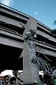
 The collapsed Cypress Street Viaduct seen from ground-level. Note detachment of upper vertical elements from lower and the lack of reinforcement at the point of detachment.
 -
 Portion of the collapsed Cypress Street Viaduct after the Loma Prieta Earthquake


Similar structures damaged by earthquakes
- Alaskan Way Viaduct (not destroyed)
- Central Freeway
- Embarcadero Freeway
- Hanshin Expressway
References
- ^ "Cypress Viaduct Freeway".
- ^ Holler, Scott (1989). "A City Trembled, Its People Held". People. 32 (18). Retrieved February 4, 1989.
{{cite journal}}: Check date values in:|accessdate=(help); Unknown parameter|coauthors=ignored (|author=suggested) (help); Unknown parameter|month=ignored (help) - ^ "Putting the "There" There: Historical Archaeologies of West Oakland". Retrieved 2007-11-03.
External links
- Miracle on Interstate 880 (1993), TV movie fictionalization and re-enactment of events at the Cypress Structure.
- Construction of the Cypress Viaduct (part 1 of 5) (1950s), Caltrans video showing the progress of construction and engineering methods used.