Den Burg
53°3′N 4°48′E / 53.050°N 4.800°E
Den Burg | |
|---|---|
 Aerial view of Den Burg | |
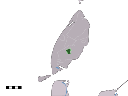
 The town centre (dark green) and the statistical district (light green) of Den Burg in the municipality of Texel. | |
 | |
| Country | Netherlands |
| Province | Noord-Holland |
| Municipality | Texel |
| Population | 7,000 |

Den Burg is a town in the Dutch province of North Holland. It is a part of the municipality of Texel on the island of the same name, and lies about 12 km north of Den Helder.
Overview
Located in the middle of the island, Den Burg is the largest city of Texel. It features a historic centre and also the town hall. Outdoor markets are held each week in the main square. Nevertheless, Den Burg is the island's least touristic settlement.
In 2001, Den Burg had 6,160 inhabitants. The built-up area of the town covers 1.47 km² and contains 2,645 residences.[1] The slightly larger statistical district "Den Burg" has a population of around 6,380.[2]
Notable sites
A monument to the constructed language, Esperanto, is on the corner of Kogerstraat and De Zes. It was constructed in 1935 when Esperanto was widely spoken throughout the island.[3]
Notable people
- Willem Eduard Bok (1846–1904), State Secretary of the South African Republic (Transvaal) 1880-1889.
- Hans Kamp (born 1940), philosopher, creator of discourse representation theory (DRT).
- Henk Zijm (born 1952), mathematician, professor and Rector Magnificus (2005–2008) at the University of Twente.
- Dorian van Rijsselberghe (born 1988), windsurfer, winner of gold medal in the 2012 Olympics.
References
External links
![]() Media related to Den Burg at Wikimedia Commons
Media related to Den Burg at Wikimedia Commons
