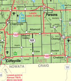
Dennis, Kansas
Appearance
Dennis, Kansas | |
|---|---|
 | |
| Coordinates: 37°20′49″N 95°24′46″W / 37.34694°N 95.41278°W | |
| Country | United States |
| State | Kansas |
| County | Labette |
| Time zone | UTC-6 (CST) |
| • Summer (DST) | UTC-5 (CDT) |
| Area code | 620 |
Dennis is an unincorporated community in Labette County, Kansas, United States.
History
Dennis had its start in the early 1880s by the building of the Memphis, Kansas and Colorado Railroad through that territory.[1] The first post office in Dennis was established in May 1881.[2]
The nearby Big Hill Archeological District is on the National Register of Historic Places.
See also
References
- ^ Blackmar, Frank Wilson (1912). Kansas: A Cyclopedia of State History, Embracing Events, Institutions, Industries, Counties, Cities, Towns, Prominent Persons, Etc. Standard Publishing Company. p. 508.
- ^ "Kansas Post Offices, 1828-1961". Kansas Historical Society. Retrieved 12 June 2014.
Further reading
External links


