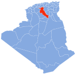
Djelfa District
Djelfa District | |
|---|---|
 | |
| Coordinates: 34°47′17.9″N 3°13′43.9″E / 34.788306°N 3.228861°E | |
| Country | |
| Province | Djelfa Province |
| Capital | Djelfa |
| Time zone | UTC+1 (CET) |
Djelfa district is an Algerian administrative district in the Djelfa province. Its capital is town of Djelfa .[1][2]
Communes
The district is composed of only one commune: Djelfa.
References
- ^ "Djelfa District". OpenSteetMap. OpenSteetMap. Retrieved 6 May 2018.
{{cite web}}: Cite has empty unknown parameter:|dead-url=(help) - ^ Amri, Kamel; et el (16 February 2017). "Mapping geology in Djelfa District (Saharan Atlas, Algeria), using Landsat 7 ETM+ data: an alternative method to discern lithology and structural elements". Arabian Journal of Geosciences. Current Advances in Geology of North Africa.

