Dooley, Arkansas
Appearance
Dooley, Arkansas | |
|---|---|
| Coordinates: 33°28′07″N 93°51′27″W / 33.46861°N 93.85750°W | |
| Country | United States |
| State | Arkansas |
| County | Miller |
| Elevation | 253 ft (77 m) |
| Time zone | UTC-6 (Central (CST)) |
| • Summer (DST) | UTC-5 (CDT) |
| Area code | 870 |
| GNIS feature ID | 56994[1] |
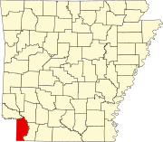
Dooley is an unincorporated community in Miller County, Arkansas, United States. Dooley is located on Arkansas Highway 296, 11.1 miles (17.9 km) north-northeast of Texarkana.[2]
References
[edit]- ^ "Dooley". Geographic Names Information System. United States Geological Survey, United States Department of the Interior.
- ^ Miller County, Arkansas General Highway Map (PDF) (Map). Arkansas State Highway and Transportation Department. 2010. Archived from the original (PDF) on April 23, 2012. Retrieved June 12, 2012.


