Dymokury
You can help expand this article with text translated from the corresponding article in Czech. (July 2009) Click [show] for important translation instructions.
|
Dymokury | |
|---|---|
Municipality and village | |
 | |
| Country | |
| Region | Central Bohemian Region |
| District | Nymburk District |
| Area | |
| • Total | 7.96 sq mi (20.62 km2) |
| Elevation | 666 ft (203 m) |
| Population (2011) | |
| • Total | 846 |
| • Density | 110/sq mi (41/km2) |
| Time zone | UTC+1 (CET) |
| • Summer (DST) | UTC+2 (CEST) |
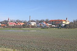
Dymokury (German: Dimokur) is a village and municipality in Nymburk District in the Central Bohemian Region of the Czech Republic.
Geography
It is located in the Polabí lowlands of the Elbe basin, about 15 km (9.3 mi) north of Poděbrady. The local economy mainly depends on agriculture and a brewery.
History

The settlement in the Kingdom of Bohemia was first mentioned in 1249, then a possession of a local noble Soběslav. In 1290 King Wenceslaus II ceded the estates to the Cistercian monks of Sedlec Abbey near Kutná Hora. After changing owners several times, the fief was purchased by the noble House of Waldstein in 1573, their successors had a Renaissance castle erected from 1614 onwards.
Disseized by Emperor Ferdinand II after the 1620 Battle of White Mountain, Dimokur was acquired by Albrecht von Wallenstein, who nevertheless sold it to the Austrian Khuen von Belasi dynasty shortly afterwards. From 1673, the House of Colloredo held the manor, which also included the neighbouring town of Městec Králové. They had the castle again rebuilt in a Baroque style, finished in 1787. The last owners were the Counts of Czernin, who were expropriated and expelled after World War II. The castle was restored after the Velvet Revolution of 1989.
External links
Notes
- This article was initially translated from the Czech Wikipedia.


