
Eagle, Wisconsin
Eagle, Wisconsin | |
|---|---|
 Looking south in downtown Eagle | |
 Location of Eagle, Wisconsin | |
| Country | United States |
| State | Wisconsin |
| County | Waukesha |
| Area | |
| • Total | 1.33 sq mi (3.44 km2) |
| • Land | 1.33 sq mi (3.44 km2) |
| • Water | 0 sq mi (0 km2) |
| Elevation | 902 ft (275 m) |
| Population | |
| • Total | 1,950 |
| • Estimate (2012[4]) | 1,952 |
| • Density | 1,466.2/sq mi (566.1/km2) |
| Time zone | UTC-6 (Central (CST)) |
| • Summer (DST) | UTC-5 (CDT) |
| Area code | 262 |
| FIPS code | 55-21450[5] |
| GNIS feature ID | 1583112[2] |
| Website | www.eagle-wi.gov |
Eagle is a village in Waukesha County, Wisconsin, United States. The population was 1,950 at the 2010 census. The village is located within the Town of Eagle.
Museums
Old World Wisconsin is in Eagle. Old World Wisconsin is a vivid open-air museum re-creating the working farmsteads and settlements established by European immigrants in America's heartland. The museum includes teams of oxen and horses working in the fields, the farm folk preparing hearty meals over wood-burning stoves, and the heirloom plants in well-tended gardens. Crossroads Village includes a shoe maker, blacksmith, 1860s and 1880s gardens and general store.[6]
Geography
Eagle is located at 42°52′39″N 88°28′18″W / 42.87750°N 88.47167°W (42.877595, -88.471918).[7]
According to the United States Census Bureau, the village has a total area of 1.33 square miles (3.44 km2), all of it land.[1]
Demographics
| Census | Pop. | Note | %± |
|---|---|---|---|
| 1880 | 292 | — | |
| 1900 | 324 | — | |
| 1910 | 339 | 4.6% | |
| 1920 | 394 | 16.2% | |
| 1930 | 392 | −0.5% | |
| 1940 | 391 | −0.3% | |
| 1950 | 460 | 17.6% | |
| 1960 | 620 | 34.8% | |
| 1970 | 745 | 20.2% | |
| 1980 | 1,008 | 35.3% | |
| 1990 | 1,182 | 17.3% | |
| 2000 | 1,707 | 44.4% | |
| 2010 | 1,950 | 14.2% | |
| 2014 (est.) | 1,953 | [8] | 0.2% |
2010 census
As of the census[3] of 2010, there were 1,950 people, 684 households, and 536 families residing in the village. The population density was 1,466.2 inhabitants per square mile (566.1/km2). There were 704 housing units at an average density of 529.3 per square mile (204.4/km2). The racial makeup of the village was 98.3% White, 0.1% African American, 0.1% Native American, 0.4% Asian, 1.0% from other races, and 0.2% from two or more races. Hispanic or Latino of any race were 2.1% of the population.
There were 684 households of which 45.2% had children under the age of 18 living with them, 68.0% were married couples living together, 6.1% had a female householder with no husband present, 4.2% had a male householder with no wife present, and 21.6% were non-families. 18.1% of all households were made up of individuals and 5.9% had someone living alone who was 65 years of age or older. The average household size was 2.85 and the average family size was 3.25.
The median age in the village was 35.3 years. 30.4% of residents were under the age of 18; 5.8% were between the ages of 18 and 24; 31.3% were from 25 to 44; 24.8% were from 45 to 64; and 7.6% were 65 years of age or older. The gender makeup of the village was 50.8% male and 49.2% female.
2000 census
As of the census[5] of 2000, there were 1,707 people, 592 households, and 468 families residing in the village. The population density was 1,346.5 people per square mile (519.0/km²). There were 605 housing units at an average density of 477.2 per square mile (183.9/km²). The racial makeup of the village was 96.49% White, 0.23% Black or African American, 0.53% Native American, 0.29% Asian, 1.35% from other races, and 1.11% from two or more races. 3.05% of the population were Hispanic or Latino of any race.
There were 592 households out of which 46.5% had children under the age of 30 living with them, 71.3% were married couples living together, 4.6% had a female householder with no husband present, and 20.8% were non-families. 17.1% of all households were made up of individuals and 6.8% had someone living alone who was 65 years of age or older. The average household size was 2.88 and the average family size was 3.28.
In the village the population was spread out with 31.6% under the age of 18, 6.2% from 18 to 24, 38.0% from 25 to 44, 17.6% from 45 to 64, and 6.6% who were 65 years of age or older. The median age was 33 years. For every 100 females there were 98.7 males. For every 100 females age 18 and over, there were 97.1 males.
The median income for a household in the village was $58,207, and the median income for a family was $62,500. Males had a median income of $41,711 versus $27,500 for females. The per capita income for the village was $21,975. About 1.4% of families and 3.1% of the population were below the poverty line, including 4.3% of those under age 18 and 2.8% of those age 65 or over.
2010 Tornado
The village was struck by an EF2 tornado on the night of June 21, 2010. Tornado alert sirens in the area failed to sound prior to the strike. There were no fatalities, but there were several minor injuries. At least 2 homes were leveled to the ground by the tornado and other homes had minor damages.[10]
Images
-
 Looking east in downtown Eagle
 -
 Fire station and EMS
 -
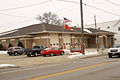
 Police station
 -
 Sign for Eagle on WIS 67
 -
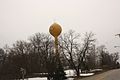 Smile on water tower
 -
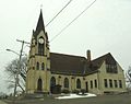 St. Theresa Catholic Church


References
- ^ a b "US Gazetteer files 2010". United States Census Bureau. Retrieved 2012-11-18.
- ^ a b "US Board on Geographic Names". United States Geological Survey. 2007-10-25. Retrieved 2008-01-31.
- ^ a b "American FactFinder". United States Census Bureau. Retrieved 2012-11-18.
- ^ "Population Estimates". United States Census Bureau. Retrieved 2013-06-24.
- ^ a b "American FactFinder". United States Census Bureau. Retrieved 2008-01-31.
- ^ http://oldworldwisconsin.wisconsinhistory.org/Explore/ExploreOverview.aspx
- ^ "US Gazetteer files: 2010, 2000, and 1990". United States Census Bureau. 2011-02-12. Retrieved 2011-04-23.
- ^ "Annual Estimates of the Resident Population for Incorporated Places: April 1, 2010 to July 1, 2014". Retrieved June 4, 2015.
- ^ "Census of Population and Housing". Census.gov. Retrieved June 4, 2015.
- ^ http://www.spc.noaa.gov/climo/reports/100621_rpts.html
External links
- Village of Eagle
- Sanborn fire insurance maps: 1894 1900
Municipalities and communities of Waukesha County, Wisconsin, United States | ||
|---|---|---|
| Cities |  | |
| Villages | ||
| Towns | ||
| CDPs | ||
| Other communities | ||
| Former communities | ||
| Footnotes | ‡This populated place also has portions in an adjacent county or counties | |