
Eaglehawk Neck
Eaglehawk Neck | |
|---|---|
 Eaglehawk Neck from Martin Cash's lookout. | |
| Location | Forestier Peninsula and Tasman Peninsula in south-eastern Tasmania, Australia |
| Dimensions | |
| • Length | 400 metres (1,300 ft) |
| • Width | 30 metres (98 ft) |
| Designation | |
| Website | eaglehawkneck |
The Eaglehawk Neck is a narrow isthmus that connects the Tasman Peninsula with the Forestier Peninsula, and hence to mainland Tasmania, Australia. A township settlement in the same region is also called Eaglehawk Neck.
Location and features
This section includes a list of general references, but it lacks sufficient corresponding inline citations. (August 2015) |
At the 2011 census, the settlement of Eaglehawk Neck had a population of 338.[1]
Locally known as the Neck, the isthmus itself is around 400 metres (1,300 ft) long and under 30 metres (98 ft) wide at its narrowest point. The area has a beautiful and rugged terrain and several unusual geological formations. These include the Tessellated Pavement, an area of flat rock that looks to be manmade but is in fact formed by erosion. Also nearby are Tasman's Arch, the Blowhole and the Devil's Kitchen, all striking natural formations.
Eaglehawk Neck offers accommodation in the Lufra Hotel, near the Tessellated Pavement, and Bluegum Hostel on Old Jetty Road. A nearby footpath leads to Martin Cash's lookout near the top of the hill at the southern end.
Eaglehawk Neck is a well-known local holiday destination. On the eastern side, a beach that stretches around Pirates' Bay is a popular surfing area. In summer the population rises as people return to their holiday homes.
European history
It forms a natural gateway between the peninsulas that was used by the British in 1830s when a line of dogs was chained to posts across the neck to warn of any convicts attempting to escape the Port Arthur prison. The area was heavily patrolled by soldiers, and the guards' quarters still remains as a museum. Many attempts were made by convicts to escape via Eaglehawk Neck, including those of Martin Cash.[2] The isthmus now provides road access via the Arthur Highway to Port Arthur, part of the Australian Convict Sites, a World Heritage Site that comprises eleven remnant penal sites originally built within the British Empire during the 18th and 19th centuries on fertile Australian coastal strips. Collectively, these sites, including Port Arthur, now represent, "...the best surviving examples of large-scale penal transportation and the colonial expansion of European powers through the presence and labour of convicts."[3]
The first Eagle Hawk Neck post office was open from 1875 until 1877. It reopened on 11 January 1895 and closed in 1974.[4]
Gallery
-
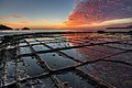 Tessellated Pavement at sunrise.
 -
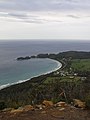 Pirates Bay and Doo Town.


See also
References
- ^ Australian Bureau of Statistics (31 October 2012). "Eaglehawk Neck (SSC) (State Suburbs)". 2011 Census QuickStats. Retrieved 8 August 2015.
- ^ Robson, L. L.; Ward, Russel (1966). "Cash, Martin (1808–1877)". Australian Dictionary of Biography. Vol. Vol. 1. National Centre of Biography, Australian National University. ISSN 1833-7538. Retrieved 8 August 2015.
{{cite encyclopedia}}:|volume=has extra text (help)CS1 maint: multiple names: authors list (link) - ^ "Australian Convict Sites". World Heritage List. UNESCO. 2010. Retrieved 2 August 2010.
- ^ "Post Office List". Premier Postal History. Premier Postal Auctions. Retrieved 16 June 2012.
Further reading
- Storey, Shirley; Storey, Peter (1990). Tasman tracks: 25 walks on the Tasman and Forestier Peninsulas. Koonya Press. ISBN 0-6460-1870-1.
External links
- Eaglehawk Neck at walkabout.com.au
- Eaglehawk Neck
South Eastern region of Tasmania, Australia | |||||
|---|---|---|---|---|---|
| Governance former | |||||
| Mountains |
| ||||
| Protected areas, parks and reserves | |||||
| Rivers | |||||
| Harbours, bays, inlets and estuaries | |||||
| Transport | |||||
| Landmarks |
| ||||
| Islands |
| ||||
| Books and newspapers | |||||
| Bioregions | |||||