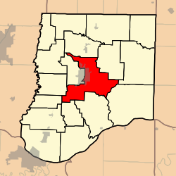
East Fulton Township, Callaway County, Missouri
East Fulton Township | |
|---|---|
 | |
| Coordinates: 38°51′12″N 091°55′48″W / 38.85333°N 91.93000°W | |
| Country | United States |
| State | Missouri |
| County | Callaway |
| Area | |
• Total | 67.04 sq mi (173.64 km2) |
| • Land | 66.85 sq mi (173.13 km2) |
| • Water | 0.2 sq mi (0.51 km2) 0.29% |
| Elevation | 791 ft (241 m) |
| Population (2010) | |
• Total | 10,231 |
| • Density | 150/sq mi (59/km2) |
| FIPS code | 29-20854[2] |
| GNIS feature ID | 0766377 |
East Fulton Township is one of eighteen townships in Callaway County, Missouri, USA. As of the 2010 census, its population was 10,231.[3]
History
[edit]The previously unified Fulton Township was founded as 'Elizabeth Township' May 14, 1821, only a few months after the initial creation of township districts in Callaway County, around the time of Missouri statehood. Its original name was due to the county seat being initially in a town called Elizabeth (not to be confused with nearby Saint Elizabeth in Miller County), about 6 miles southeast of Fulton, not far from the settlement of Hams Prairie.[4] The county seat was soon moved to Fulton, instead, and the larger township district was renamed Fulton Township Feb 7, 1825. Its original boundaries were different from those of Fulton Township by the year 2000, before its division into West and then East Fulton—the original boundaries stretched from an area a few miles north of Fulton to the Missouri River, and included what, around 1855, became Saint Aubert Township (including Mokane) and most of what became Caldwell Township in 1883.[5] Then, over time, areas further north of Fulton, including the historic village of Callaway, were added to the unified, historical Fulton Township. Details of boundary changes can be found in the various official Callaway County Atlases, three of which are found in one volume[6] and, individually, on the website of the State of Missouri Historical Society [1].
Geography
[edit]East Fulton Township covers an area of 67.04 square miles (173.6 km2) and contains the east portion of the city of Fulton (the county seat). It contains seven cemeteries: Dunlap, Guerrart, Hillcrest, Kibby, Muir, Southside and United Brethren.
The streams of Booth Branch, Cow Creek, Craghead Branch, Crows Fork Creek, Dunlap Creek, Rockhouse Creek, Smith Branch and Youngs Creek run through this township.
References
[edit]- ^ "US Board on Geographic Names". United States Geological Survey. October 25, 2007. Retrieved January 31, 2008.
- ^ "U.S. Census website". United States Census Bureau. Retrieved January 31, 2008.
- ^ "Race, Hispanic or Latino, Age, and Housing Occupancy: 2010 Census Redistricting Data (Public Law 94-171) Summary File (QT-PL), East Fulton township, Callaway County, Missouri". United States Census Bureau. Retrieved October 31, 2011.
- ^ Provines, John G: "History of Callaway County" article in 1876 "Illustrated Historical Atlas of Callaway County". Philadelphia PA: Edwards Brothers, 1876.
- ^ Missouri State Library. "History of Callaway County". St Louis MO: National Historical Company, 1884.
- ^ Kingdom of Callaway Historical Society. "Combined Atlases of Callaway County Missouri 1876-1897-1919, Indexed". Mt Vernon IN: Windmill Publications, 1994.
External links
[edit]

