East Coast Trail
| East Coast Trail | |
|---|---|
 | |
| Length | 540 km (340 mi) |
| Location | Newfoundland, Canada |
| Trailheads | Near St. John's; Cappahayden |
| Use | Hiking |
The East Coast Trail is a 540 kilometres (340 mi) long-distance footpath located in the Canadian province of Newfoundland and Labrador.
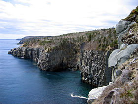
Located primarily on public lands, the trail traces the east coast of Newfoundland along the Atlantic Ocean. The trail passes through many small coastal towns nested in the bays of the Avalon Peninsula between St. John's and Cappahayden. Major attractions include the Spout, a natural water spout created by wave action along the rocky coast, coastal barachois formations, and a suspension bridge near the abandoned community of La Manche. The trail also passes through Cape Spear, the easternmost point in North America.
265 kilometres (165 mi) of the trail (between Cape St. Francis and Cappahayden) are fully mapped and have proper signage. The remaining 275 kilometres (171 mi) of the trail are accessible to the public, but are unsigned and considered to be 'under construction'.[1]

External links
References
- ^ "East Coast Trail (Trail Overview)". East Coast Trail Association. Retrieved 2007-07-01.
