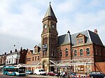
Edge Lane railway station
Edge Lane | |
|---|---|
| General information | |
| Location | Liverpool |
| Coordinates | 53°24′36″N 2°55′38″W / 53.4099°N 2.9272°W |
| Platforms | 2[1] |
| History | |
| Original company | London and North Western Railway |
| Pre-grouping | London and North Western Railway |
| Post-grouping | London, Midland and Scottish Railway |
| Key dates | |
| November 1870 | Opened[2] |
| 31 May 1948 | Closed[2][3] |
Edge Lane railway station was on the Canada Dock Branch in Liverpool, England.
The station opened in September 1870 and closed on 31 May 1948. Freight trains to and from Seaforth Docks still pass through the station site.
References
Sources
- Butt, R. V. J. (October 1995). The Directory of Railway Stations: details every public and private passenger station, halt, platform and stopping place, past and present (1st ed.). Sparkford: Patrick Stephens Ltd. ISBN 978-1-85260-508-7. OCLC 60251199. OL 11956311M.
- Gell, Rob (1985). An Illustrated Survey of Liverpool's Railway Stations 1830-1985. Crosby, Merseyside: Heyday Publishing. ISBN 978-0-947562-03-8.
{{cite book}}: Invalid|ref=harv(help)
External links
- The station's history Disused Stations
- The station and local lines on multiple maps Rail Maps Online
- The station on an Edwardian 25" OS map National Library of Scotland
- The branch with stations and mileages Railway Codes
| Preceding station | Disused railways | Following station | ||
|---|---|---|---|---|
| Stanley Line and station closed |
London and North Western Railway Canada Dock Branch |
Edge Hill Line closed, station open | ||
| London and North Western Railway Olive Mount chord |
Broad Green Line closed, station open |


