Ie, Noardeast-Fryslân
Appearance
You can help expand this article with text translated from the corresponding article in Western Frisian. (February 2009) Click [show] for important translation instructions.
|
Ee
Ie | |
|---|---|
Village | |
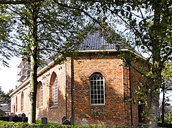
 St Gangulf church | |
 Location in the Dongeradeel municipality | |
| Coordinates: 53°19′48″N 6°06′00″E / 53.33000°N 6.10000°E | |
| Country | |
| Province | |
| Municipality | |
| Population (2017) | |
| • Total | 834 |
| Time zone | UTC+1 (CET) |
| • Summer (DST) | UTC+2 (CEST) |
| Postal code | 9131 |
| Telephone area | 0519 |
| Website | Official |

Ee (Dutch pronunciation: [eː]) (West Frisian: Ie) is a village in the northern Netherlands. It is located in the municipality of Dongeradeel, Friesland, east of Dokkum. Ee had approximately 834 inhabitants in January 2017.[1]
There are various types of buildings in Ee, including a church built in 1220. The only flax museum of the Netherlands is also located in Ee. Ee has mostly remained an intact rural village.
Ee has the shortest name of all places in the Netherlands.
Transportation
The N 358 passes through town.
Bus routes 63 and 562 connect Ee with Dokkum.
References
External links
Wikimedia Commons has media related to Ie, Noardeast-Fryslân.


