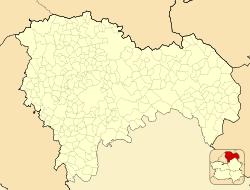
El Casar
El Casar, Spain | |
|---|---|
 | |
| Coordinates: 40°42′12″N 3°25′35″W / 40.70333°N 3.42639°W | |
| Country | |
| Autonomous community | Castile-La Mancha |
| Province | Guadalajara |
| Municipality | El Casar |
| Area | |
| • Total | 51 km2 (20 sq mi) |
| Population (2013) | |
| • Total | 11,635 |
| • Density | 224.44/km2 (581.3/sq mi) |
| Time zone | UTC+1 (CET) |
| • Summer (DST) | UTC+2 (CEST) |
El Casar is a municipality located in the province of Guadalajara, Castile-La Mancha, Spain. According to the 2013 census (INE), the municipality has a population of 11,635 inhabitants.
Educational Centres
- El Casar has 5 state schools and one private school:
- State schools: CEIP Maestros de El Casar, CEIP El Coto, CEIP Los Arenales, IES Juan Gacía Valdemora y el IES Campiña Alta.
- Private School: Colegio Privado Montealbir.
- El Casar has the educational centre The School English Institute.


