Elizaville, Indiana
Appearance
Elizaville | |
|---|---|
 Elizaville Baptist Church | |
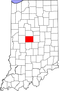
 Boone County's location in Indiana | |
| Coordinates: 40°07′36″N 86°22′33″W / 40.12667°N 86.37583°W | |
| Country | United States |
| State | Indiana |
| County | Boone |
| Township | Clinton |
| Elevation | 928 ft (283 m) |
| ZIP code | 46052 |
| FIPS code | 18-20710[1] |
| GNIS feature ID | 434073[2] |
Elizaville is an unincorporated community in Clinton Township, Boone County, Indiana, United States.
History
A post office was established at Elizaville in 1855, and remained in operation until it was discontinued in 1907.[3]
Geography
Elizaville is located at 40°07′36″N 86°22′33″W / 40.12667°N 86.37583°W.
References
- ^ "American FactFinder". United States Census Bureau. Archived from the original on 2013-09-11. Retrieved 2008-01-31.
{{cite web}}: Unknown parameter|deadurl=ignored (|url-status=suggested) (help) - ^ "Elizaville, Indiana". Geographic Names Information System. United States Geological Survey, United States Department of the Interior. Retrieved 2009-10-17.
- ^ "Boone County". Jim Forte Postal History. Archived from the original on 3 September 2014. Retrieved 26 August 2014.
{{cite web}}: Unknown parameter|deadurl=ignored (|url-status=suggested) (help)


