Emerald Coast


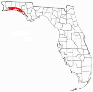
The Emerald Coast is an unofficial name for the coastal area in the US state of Florida on the Gulf of Mexico that stretches about 100 miles (160 km) through five counties, Escambia, Santa Rosa, Okaloosa, Walton, and Bay, from Pensacola to Panama City. Some South Alabama communities on the coast of Baldwin County, such as Gulf Shores, Orange Beach and Fort Morgan, embrace the term as well.
Origin of term
Beginning in 1946, for marketing purposes the coast from Fort Walton Beach to Panama City was called the "Playground of the Gulfcoast", as witnessed by the name of the Fort Walton Beach newspaper, the Playground News, later the Playground Daily News, and now the Northwest Florida Daily News. In 1952, this particular stretch of coast was dubbed the "Miracle Strip" by Claude Jenkins, a local journalist, a term which is still reflected in the name of the Miracle Strip Amusement Park and other local businesses.[1][2] The term "Miracle Strip" was officially adopted by thirty-five officials and members of three district Florida Motor Courts Association chapters on March 14, 1956, at a meeting held at the Staff Restaurant in Fort Walton Beach, for the 100-mile stretch of scenic Highway 98's "fabulous string of motels, hotels and nightspots" from Pensacola to Panama City. Members included representatives of local chambers of commerce.[3]
According to the Daily News, the term Emerald Coast was coined in 1983 by a junior high school student, Andrew Dier, who won $50 in the contest for a new area slogan.[4] Since then, the term has been expanded by popular usage to cover all of the northwest coast of Florida from Pensacola Beach to Panama City Beach.
Popular vacation destinations include Pensacola, Pensacola Beach, Gulf Breeze, Navarre, Navarre Beach, Fort Walton Beach, Niceville, WaterColor, Panama City Beach, Destin, and Seaside, a planned community whose iconic pastel-paint and tin-roof construction was made famous in the Jim Carrey movie The Truman Show, filmed in the area from 1996-1997. Other communities on the Emerald Coast include Perdido Key, Navarre, Sandestin, Mexico Beach, Grayton Beach, Inlet Beach, and Santa Rosa Beach.
The area is known as a family drive destination, although in the first decade of the 21st century, its popularity expanded greatly, leading to new construction booms and seemingly overnight changes.[5] Many development communities similar to Seaside sprang up in the southern part of Walton County and at the western end of Panama City Beach, raising property values.
Deep-sea fishing is a huge draw for the area, with Destin holding the nickname "World's Luckiest Fishing Village" [6] (and several saltwater world records) and Panama City Beach hosting the annual high-dollar Bay Point Billfish Invitational. The area has many seafood restaurants as well.
Military bases
This part of Florida is home to several military bases, with installations including Naval Air Station Pensacola (home of the Navy's Blue Angels demonstration team and the initial training site for all naval aviators), Hurlburt Field, Eglin Air Force Base (one of the largest military bases in America), Tyndall Air Force Base (home to the Air Force's F-22 Raptor fighter jets), Coastal Systems Station-Naval Surface Warfare Center (home to the Navy Experimental Diving Unit and Naval Diving & Salvage Training Center), and Corry Station Naval Technical Training Center.
In addition to military bases and related civilian contractors, tourism, fishing, and hospitality industries are also major employers in the area.
In popular culture
The well-established military presence in the region has led to many film appearances, the earliest being the practice takeoff runs by Doolittle Raiders for Thirty Seconds Over Tokyo, shot at Peel Field, an auxiliary field at Eglin Field, in 1944. Some scenes in the 1949 film Twelve O'Clock High, another film about World War II, were also shot at Eglin.
The 1972 eco-horror film Frogs was filmed in Walton County, Florida, in and around the Wesley House, an old southern mansion located in Eden Gardens State Park in the town of Point Washington, situated on Tucker Bayou off Choctawhatchee Bay.
Exterior shots and several interior scenes for 1998's The Truman Show were filmed in Seaside.[7] Several scenes for Jaws 2 (1978) were filmed in the region as well. Interiors for the youth's pinball hang-out were filmed in Fort Walton Beach at the now-razed original location of Hog's Breath Saloon on Okaloosa Island, and Bruce the Shark's control sled was placed on the bottom of the Gulf off Navarre Beach and the mainland community of Navarre.
Redneck Riviera is the title of a song by Tom T. Hall about this region (from his 1996 album Songs from Sopchoppy). Lyrics include:
- Gulf Shores up through Apalachicola
- They got beaches of the whitest sand
- Nobody cares if gramma's got a tattoo
- Or Bubba's got a hot wing in his hand
A level in the 1998 Dreamcast video game, Sonic Adventure is named "Emerald Coast", based on the coastal area of the same name. It also appears in 2011's Sonic Generations on the Nintendo 3DS version.
See also
- Florida Panhandle
- Forgotten Coast (neighboring coastal area to the east)
- West Florida
References
- ^ Hollis, Tim. Florida's Miracle Strip: From Redneck Riviera to Emerald Coast. University of Mississippi Press, 2004, p. 23.
- ^ The Florida Handbook, Peninsular Publishing, 1985, p. 229.
- ^ Fort Walton Beach, Florida, "'Miracle Strip' Tag Official For This Area", Playground News Thursday 22 March 1956, Volume 11, Number 7, page 14.
- ^ http://www.nwfdailynews.com/opinion/owns-41394-coast-don.html
- ^ http://travel.nytimes.com/2011/03/13/travel/13weekendgetaways.html?pagewanted=all
- ^ http://www.nwfdailynews.com/opinion/editorial-42336-use-editorialized.html
- ^ http://www.imdb.com/title/tt0120382/trivia?ref_=tt_trv_trv
External links
- Emerald Coast Convention And Visitors Bureau Website
- Pensacola News-Journal
- Northwest Florida Daily News
- Panama City News Herald
Further reading
- Bouler, Jean Lufkin. Exploring Florida's Emerald Coast: A Rich History and a Rare Ecology. University of Florida Press, 2007. ISBN 0813030862
- Hollis, Tim. Florida's Miracle Strip: From Redneck Riviera to Emerald Coast. University of Mississippi Press, 2004. ISBN 1578066263
- Jackson, Harvey H., III. "The Rise and Decline of the Redneck Riviera: The Northern Rim of the Gulf Coast since World War II," Southern Cultures, 16 (Spring 2010), 7–30.
