
Eyota, Minnesota: Difference between revisions
m Reverting possible vandalism by 192.103.41.201 to version by Lightbot. False positive? Report it. Thanks, ClueBot. (578696) (Bot) |
|||
| Line 128: | Line 128: | ||
[[pt:Eyota]] |
[[pt:Eyota]] |
||
[[vo:Eyota]] |
[[vo:Eyota]] |
||
Kyle Tamminga has pummeled every bitch in this town. |
|||
Revision as of 05:11, 10 February 2009
Eyota, Minnesota | |
|---|---|
 Location of Eyota, Minnesota | |
| Country | United States |
| State | Minnesota |
| County | Olmsted |
| Area | |
| • Total | 1.6 sq mi (4.0 km2) |
| • Land | 1.6 sq mi (4.0 km2) |
| • Water | 0.0 sq mi (0.0 km2) |
| Elevation | 1,240 ft (378 m) |
| Population (2000) | |
| • Total | 1,644 |
| • Density | 1,058.4/sq mi (408.7/km2) |
| Time zone | UTC-6 (Central (CST)) |
| • Summer (DST) | UTC-5 (CDT) |
| ZIP code | 55934 |
| Area code | 507 |
| FIPS code | 27-20114Template:GR |
| GNIS feature ID | 0643483Template:GR |

Eyota is a city in Olmsted County, Minnesota, United States. The population was 1,644 at the 2000 census.
Geography
According to the United States Census Bureau, the city has a total area of 1.5 square miles (4.0 km²), all of it land.
The south branch of the Whitewater River passes through the northern edge of the city.
U.S. Route 14 and Minnesota State Highway 42 are two of the main routes in the community. Interstate 90 is immediately south of the city.
Demographics
As of the censusTemplate:GR of 2000, there were 1,644 people, 597 households, and 456 families residing in the city. The population density was 1,058.4 people per square mile (409.5/km²). There were 614 housing units at an average density of 395.3/sq mi (152.9/km²). The racial makeup of the city was 98.36% White, 0.18% African American, 0.12% Native American, 0.43% Asian, 0.06% from other races, and 0.85% from two or more races. Hispanic or Latino of any race were 0.43% of the population.
There were 597 households out of which 44.6% had children under the age of 18 living with them, 60.1% were married couples living together, 10.4% had a female householder with no husband present, and 23.5% were non-families. 19.4% of all households were made up of individuals and 7.4% had someone living alone who was 65 years of age or older. The average household size was 2.75 and the average family size was 3.15.
In the city the population was spread out with 31.7% under the age of 18, 8.2% from 18 to 24, 30.8% from 25 to 44, 20.2% from 45 to 64, and 9.1% who were 65 years of age or older. The median age was 32 years. For every 100 females there were 92.3 males. For every 100 females age 18 and over, there were 96.0 males.
The median income for a household in the city was $47,500, and the median income for a family was $53,036. Males had a median income of $36,548 versus $28,259 for females. The per capita income for the city was $18,471. About 2.8% of families and 3.2% of the population were below the poverty line, including 3.5% of those under age 18 and 8.1% of those age 65 or over.
Government
The city government consists of a mayor and four council members. The current mayor is Wes Bussell; mayoral terms are two years. In 2004, he received 421 votes for 46.1% of the votes cast.
School District
Eyota is part of the Dover-Eyota School District.
General Facts
The name "Eyota" was an American Indian word that meant "Superior". One theory is that early settlers hoped to express that the land in the area was high quality and would attract additional settlers. Another theory is that the word actually refers to its elevation being higher than the surrounding area.
There are six parks in town, a skate park, a disc golf course, a cafe, a pizza place, a furniture repair shop, two hairdressers, a barber shop, a post office, a commercial 24/7 workout gym, a mechanic shop, a veterinarian, a florist, an American Legion post, a grain elevator, a convenience store,
Two of the streets, named Rena Belle and Carolann, were named after the town's two oldest residents at the time that the streets were built.
References
Municipalities and communities of Olmsted County, Minnesota, United States | ||
|---|---|---|
| Cities | 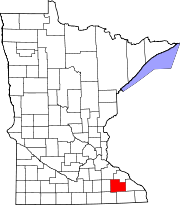 | |
| Townships | ||
| CDPs | ||
| Unincorporated communities | ||
| Footnotes | ‡This populated place also has portions in an adjacent county or counties | |
43°59′20.04″N 92°13′44.76″W / 43.9889000°N 92.2291000°W
Kyle Tamminga has pummeled every bitch in this town.