
File:Mongol Empire c.1207.png

Size of this preview: 800 × 523 pixels. Other resolutions: 320 × 209 pixels | 640 × 419 pixels | 813 × 532 pixels.
Original file (813 × 532 pixels, file size: 311 KB, MIME type: image/png)
| This is a file from the Wikimedia Commons. Information from its description page there is shown below. Commons is a freely licensed media file repository. You can help. |
Summary
| Description |
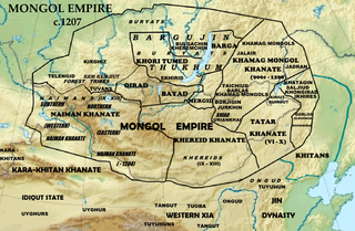
English: Map of the homelands of the tribes of the Mongol Empire in 1207 and preceding polities. Based on File:Asia laea relief location map.jpg. |
| Date | |
| Source | Data source: "Mongolian National Atlas", 2009; Atwood, Christopher P. (2004) Encyclopedia of Mongolia and the Mongol Empire, Facts on File, p. 390 ISBN: 978-0-8160-4671-3. |
| Author | Khiruge |
Licensing
I, the copyright holder of this work, hereby publish it under the following license:
This file is licensed under the Creative Commons Attribution-Share Alike 4.0 International license.
- You are free:
- to share – to copy, distribute and transmit the work
- to remix – to adapt the work
- Under the following conditions:
- attribution – You must give appropriate credit, provide a link to the license, and indicate if changes were made. You may do so in any reasonable manner, but not in any way that suggests the licensor endorses you or your use.
- share alike – If you remix, transform, or build upon the material, you must distribute your contributions under the same or compatible license as the original.
File history
Click on a date/time to view the file as it appeared at that time.
| Date/Time | Thumbnail | Dimensions | User | Comment | |
|---|---|---|---|---|---|
| current | 04:58, 22 September 2014 | | 813 × 532 (311 KB) | Khiruge | User created page with UploadWizard |
File usage
The following pages on the English Wikipedia use this file (pages on other projects are not listed):
- Barga Mongols
- Bayads
- Borjigin
- Buryats
- Genghis Khan
- History of the Khitans
- Hö'elün
- Jalairs
- Keraites
- Khamag Mongol
- Khongirad
- List of Mongol states
- List of medieval Mongol tribes and clans
- Merkit
- Mongol Empire
- Oirats
- Ongud
- Taichiud
- Tatar confederation
- Tumed
- Tuoba
- Tuyuhun
- Uriankhai
- User:AirshipJungleman29/Genghis Khan
- User:Ajrun Amir'za-da
- User:Eraalinsque/Найман мемлекеті
- User:Falcaorib
Global file usage
The following other wikis use this file:
- Usage on af.wikipedia.org
- Usage on ar.wikipedia.org
- Usage on arz.wikipedia.org
- Usage on ast.wikipedia.org
- Usage on azb.wikipedia.org
- Usage on az.wikipedia.org
- Usage on ba.wikipedia.org
- Usage on be.wikipedia.org
- Usage on bg.wikipedia.org
- Usage on bn.wikipedia.org
- Usage on bs.wikipedia.org
- Usage on bxr.wikipedia.org
- Usage on ce.wikipedia.org
- Usage on ckb.wikipedia.org
- Usage on cs.wikipedia.org
- Usage on cv.wikipedia.org
- Usage on da.wikipedia.org
- Usage on de.wikipedia.org
- Usage on eo.wikipedia.org
- Usage on es.wikipedia.org
- Usage on et.wikipedia.org
- Usage on fa.wikipedia.org
View more global usage of this file.