Florey, Australian Capital Territory
| Florey Canberra, Australian Capital Territory | |||||||||||||||
|---|---|---|---|---|---|---|---|---|---|---|---|---|---|---|---|
 | |||||||||||||||
| Population | 5,105 (2006 census)[1] | ||||||||||||||
| Established | 1980 | ||||||||||||||
| Postcode(s) | 2615 | ||||||||||||||
| District | Belconnen | ||||||||||||||
| Federal division(s) | Fraser | ||||||||||||||
| |||||||||||||||

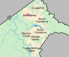
Florey (postcode: 2615) is a residential suburb of Canberra, Australian Capital Territory, Australia, in the district of Belconnen. It was gazetted on 5 August 1975 and most houses were constructed in the mid 1980s. A minor industrial area was located in the suburb prior to residential development.
The streets of Florey are named after Australian scientists. The suburb itself is named after Howard Florey, Baron Florey, who shared the Nobel Prize in Physiology or Medicine in 1945 for his role in the extraction of penicillin.
Location
Florey is the closest suburb to the Belconnen Town Centre (other than the suburb of Belconnen itself), and has its own shopping centre, on the corner of Kesteven Street and Ratcliffe Crescent. The shopping centre displays a bronze plaque explaining the significance of Lord Florey's life and work.
Education
The suburb supports three schools, the Catholic St. Francis Xavier College (7-12) and St John's Primary (K-6), and the government-run Florey Primary School which is currently one of the best schools in the Australian Capital Territory.
Geology
Going from the North east corner to the south west we pass bands of the following rocks all of Silurian age:
- Green grey dacite and quartz andesite of the Hawkins Volcanics
- The Deakin Fault
- Calcareous shale from the Yass Subgroup
- green grey and purple rhyodacite
- purple rhyodacite
- pink rhyolite
- purple-pink rhyolite
References

Footnotes
- ^ Australian Bureau of Statistics (25 October 2007). "Florey (State Suburb)". 2006 Census QuickStats. Retrieved 2009-04-09.
