
Fruitdale, Alabama
Fruitdale, Alabama | |
|---|---|
| Country | United States |
| State | Alabama |
| County | Washington |
| Area | |
| • Total | 4.491 sq mi (11.63 km2) |
| • Land | 4.474 sq mi (11.59 km2) |
| • Water | 0.017 sq mi (0.04 km2) |
| Elevation | 246 ft (75 m) |
| Population | |
| • Total | 185 |
| • Density | 41/sq mi (16/km2) |
| Time zone | UTC-6 (Central (CST)) |
| • Summer (DST) | UTC-5 (CDT) |
| Area code | 251 |
| GNIS feature ID | 118737[3] |
Fruitdale is a census-designated place and unincorporated community in Washington County, Alabama, United States. Its population was 185 as of the 2010 census.[2] Fruitdale High School serves K-12 students in the area.
References
- ^ "US Gazetteer files: 2010, 2000, and 1990". United States Census Bureau. 2011-02-12. Retrieved 2011-04-23.
- ^ a b "American FactFinder". United States Census Bureau. Retrieved 2011-05-14.
- ^ "Fruitdale". Geographic Names Information System. United States Geological Survey, United States Department of the Interior.
Municipalities and communities of Washington County, Alabama, United States | ||
|---|---|---|
| Towns | 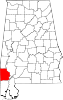 | |
| CDPs | ||
| Unincorporated communities | ||
| Ghost towns | ||
| Indian reservation | ||
| Footnotes | ‡This populated place also has portions in an adjacent county or counties | |
This Alabama state location article is a stub. You can help Wikipedia by expanding it. |