G Line (RTD)
| G Line | |||
|---|---|---|---|
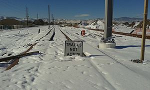
 Gold Line covered in snow near the Ward Road station. | |||
| Overview | |||
| Status | Under construction | ||
| Owner | Regional Transportation District | ||
| Locale | Denver Metropolitan Area | ||
| Termini | |||
| Stations | 8 | ||
| Service | |||
| Type | Commuter rail | ||
| System | Regional Transportation District | ||
| Operator(s) | Denver Transit Partners | ||
| History | |||
| Opened | 2016 | ||
| Technical | |||
| Line length | 11.2 miles (18.0 km) | ||
| Track gauge | 4 ft 8+1⁄2 in (1,435 mm) standard gauge | ||
| |||
The G Line, also known as the Gold Line during construction,[1] is a Regional Transportation District (RTD) electric commuter rail line between Denver Union Station and Wheat Ridge, Colorado scheduled to open in 2016.[2]
History
The Gold Line is part of the RTD’s FasTracks expansion plan, and will be operated by Denver Transit Partners as part of the Eagle P3 public–private partnership.[3] The line received a Record of Decision approval from the Federal Transit Administration in November 2009 allowing the line to be developed.[4] Groundbreaking for the line occurred on 31 August 2011, at a ceremony in Olde Town Arvada where US Transportation Secretary Ray LaHood announced the approval of a $1 billion grant to fund the project.[5] Completion of the line is expected in 2016.[3]
The line will be 11.2 miles (18.0 km) in length,[5] and is expected to cost $590.5 million.[4] There will be a total of eight stations: Union Station, 41st Avenue, Pecos, Federal, Sheridan, Olde Town, Arvada Ridge and Ward Road.[4]
The first discovery of gold, June 1850, in Colorado was in Ralston Creek, named for Lewis Ralston a Georgia prospector. A creek which runs a few blocks from the Olde Town Station.[6]
Route
The G Line's southern terminus is at Union Station in Denver. It runs on a railroad right-of-way north sharing track with the B Line until the Pecos Station after which the two routes diverge. The G Line continues west to its terminus in Wheat Ridge.[7]
Stations
| Name | Opening Year | Interchange | Municipality / CDP | park-n-Ride? | Status |
|---|---|---|---|---|---|
| colspan=6 style="background:#Template:RTD color; color:white" | G Line (Union Station – Wheat Ridge / Ward) | |||||
| Union Station/ Lower Downtown (LoDo)/ Coors Field/16th Street Mall |
2014 | A & B Lines C , E , & W Lines FREE MallRide (16th St) |
Denver | No | Open |
| Template:RTD stations | 2016 | None | Denver | Yes | Under Construction |
| Template:RTD stations | 2016 | None | North Washington | Yes | Under Construction |
| Template:RTD stations | 2016 | None | Berkley | Yes | Under Construction |
| Template:RTD stations | 2016 | None | Arvada | Yes | Under Construction |
| Template:RTD stations | 2016 | None | Arvada | Yes | Under Construction |
| Template:RTD stations | 2016 | None | Arvada | Yes | Under Construction |
| Template:RTD stations | 2016 | None | Wheat Ridge | Yes | Under Construction |
References
- ^ http://www.rtd-denver.com/g-line.shtml
- ^ "RTD - G Line". Regional Transportation District. Retrieved 22 June 2015.
- ^ a b "Eagle P3 Commuter Rail Project, Denver, USA". Railway Technology. Retrieved 1 September 2011.
- ^ a b c "Fastracks Gold Line To Wheat Ridge Approved". The Denver Channel. 3 November 2009. Retrieved 3 September 2011.
- ^ a b "USDOT provides $1 billion for Denver RTD's Eagle P3 commuter-rail project". Progressive Railroading. 1 September 2011. Retrieved 2 September 2011.
- ^ "Stories Along the Line: Gold Line carries a rich name". Regional Transportation District. Retrieved 4 June 2015.
- ^ "RTD - Northwest Rail Line - Project Map". Regional Transportation District. Retrieved February 11, 2015.

