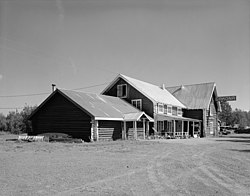
Gakona Historic District
Appearance
Gakona Historic District | |
 | |
| Location | Mile 2, Tok Cutoff-Glenn Hwy, Gakona, Alaska |
|---|---|
| Coordinates | 62°18′10″N 145°18′12″W / 62.30278°N 145.30333°W |
| Area | 7 acres (2.8 ha) |
| Built | 1904 |
| NRHP reference No. | 01000024[1] |
| Added to NRHP | February 2, 2001 |
The Gakona Historic District encompasses the historic settlement of Gakona, Alaska, which was established as a stagecoach stop on what is now the Glenn Highway in eastern Alaska. The district includes the original Gakona Roadhouse, dating to 1904, and a cluster of buildings around the 1926-28 Gakona Lodge just to its south: two cabins, a horse barn, carriage house, bar, and house. All but two of these are of log construction, and most were built either c. 1904 or 1926-28, when the highway was rebuilt to a higher standard.[2]
The district was listed on the National Register of Historic Places in 2001.[1]
See also
References
- ^ a b "National Register Information System". National Register of Historic Places. National Park Service. July 9, 2010.
- ^ "NRHP nomination for Gakona Historic District". National Park Service. Retrieved 2014-12-04.
Wikimedia Commons has media related to Gakona Historic District.

