
Goobertown, Arkansas
Goobertown, Arkansas | |
|---|---|
 Goobertown, Arkansas  Goobertown, Arkansas | |
| Coordinates: 35°57′05″N 90°34′32″W / 35.95139°N 90.57556°W | |
| Country | United States |
| State | Arkansas |
| County | Craighead |
| Elevation | 312 ft (95 m) |
| Time zone | UTC-6 (Central (CST)) |
| • Summer (DST) | UTC-5 (CDT) |
| Area code | 870 |
| GNIS feature ID | 77034[1] |
Goobertown is an unincorporated community in Craighead County, Arkansas, United States. Goobertown is located on U.S. Route 49, 10.4 miles (16.7 km) northeast of Jonesboro.[2]
References
- ^ a b U.S. Geological Survey Geographic Names Information System: Goobertown, Arkansas
- ^ Craighead County, Arkansas General Highway Map (PDF) (Map). Arkansas State Highway and Transportation Department. 2009. Archived from the original (PDF) on September 2, 2011. Retrieved September 19, 2012.
Municipalities and communities of Craighead County, Arkansas, United States | ||
|---|---|---|
| Cities | 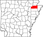 | |
| Towns | ||
| CDP | ||
| Other unincorporated communities | ||
| Ghost town | ||
This article about a property in Craighead County, Arkansas on the National Register of Historic Places is a stub. You can help Wikipedia by expanding it. |