
Grand Marais, Minnesota
Grand Marais, Minnesota | |
|---|---|
 Location of Grand Marais, Minnesota | |
| Country | United States |
| State | Minnesota |
| County | Cook |
| Area | |
• Total | 2.7 sq mi (6.9 km2) |
| • Land | 2.7 sq mi (6.9 km2) |
| • Water | 0.0 sq mi (0.0 km2) |
| Elevation | 617 ft (188 m) |
| Population (2000) | |
• Total | 1,353 |
| • Density | 506.7/sq mi (195.6/km2) |
| Time zone | UTC-6 (Central (CST)) |
| • Summer (DST) | UTC-5 (CDT) |
| ZIP code | 55604 |
| Area code | 218 |
| FIPS code | 27-24992Template:GR |
| GNIS feature ID | 0656425Template:GR |


Grand Marais is a city in Cook County, Minnesota, United States. The population was 1,353 at the 2000 census. It is the county seat of Cook County.6 Grand Marais is French for “Big Marsh,” but there is no big marsh in the vicinity of Grand Marais. Instead, historians speculate that in the French dialect spoken by the early voyageurs the word marais meant harbor or haven. If that is the case, then Grand Marais means “Big Harbor.” Similarly, the Ojibwe name for Grand Marais is “Kitchi-Bitobig” which means, “double body of water,” a reference to the two bays which form the large, welcoming Lake Superior harbor of Grand Marais.
Geography
According to the United States Census Bureau, the city has a total area of 2.7 square miles (6.9 km²), all of it land. Grand Marais is located on the northwestern shore of Lake Superior in northeastern Minnesota, and is well known as an entry point for the Boundary Waters Canoe Area Wilderness. The Superior Hiking Trail passes near Grand Marais and Judge C. R. Magney State Park is nearby with the peculiar Devil's Kettle waterfalls.
Road access to Grand Marais is by Minnesota Highway 61, which generally follows the shore of Lake Superior and is known as the North Shore Scenic Drive. The Gunflint Trail (Cook County 12) begins in Grand Marais and heads northeast away from the lake and into the Boundary Waters region. A very popular lumber mill is located here, Hedstrom Lumber Mill.
Demographics
As of the census2 of 2000, there were 1,353 people, 645 households, and 341 families residing in the city. The population density was 506.7 people per square mile (195.7/km²). There were 722 housing units at an average density of 270.4/sq mi (104.4/km²). The racial makeup of the city was 94.97% White, 2.81% Native American, 0.15% Asian, 0.15% Pacific Islander, 0.07% from other races, and 1.85% from two or more races. Hispanic or Latino of any race were 0.74% of the population.
There were 645 households out of which 23.3% had children under the age of 18 living with them, 42.9% were married couples living together, 8.1% had a female householder with no husband present, and 47.1% were non-families. 42.0% of all households were made up of individuals and 21.6% had someone living alone who was 65 years of age or older. The average household size was 2.01 and the average family size was 2.73.
In the city the population was spread out with 18.8% under the age of 18, 6.1% from 18 to 24, 25.9% from 25 to 44, 22.8% from 45 to 64, and 26.3% who were 65 years of age or older. The median age was 45 years. For every 100 females there were 83.1 males. For every 100 females age 18 and over, there were 80.8 males.
The median income for a household in the city was $33,493, and the median income for a family was $46,563. Males had a median income of $31,500 versus $23,393 for females. The per capita income for the city was $21,863. About 7.4% of families and 10.0% of the population were below the poverty line, including 11.9% of those under age 18 and 12.0% of those age 65 or over.
Gallery
-
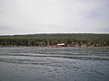
 The view of downtown Grand Marais and Lake Superior upon entering the area on Minnesota State Highway 61.
 -
 View of the Lake Superior.
 -
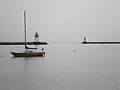 The Grand Marais harbor entrance.
 -
 A view of Lake Superior from the municipal campground beach area.
 -
 An evening view of Lake Superior.
 -
 Seagulls in Grand Marais.
 -
 The Beaver House baitshop in downtown Grand Marais.
 -
 A view of the hillside in from the harbor.
 -
 Beaver House Baitshop from a different angle
 -
 Rocks in the harbor
 -
 Sven and Olé's Pizza


Media
- Cook County News-Herald
- Cook County Star Newspaper
- WTIP Local Radio 90.7 FM
- MN Public Radio 89.7 News & 88.7 Classical
Activities
- Boundary Water's Canoe Area (BWCA) Permits
- Isle Royale National Park
- Superior Hiking Trail Association
- Grand Portage National Monument
- Cascade River State Park
- Eagle Mountain, Minnesota's highest point
- Gunflint Trail Information Center
- Judge C. R. Magney State Park
- The Border Route Trail a 65-mile long hiking trail
- Gunflint Trail Information
External links
- Grand Marais' City Government Website
- Grand Marais' Area Tourism Association Website
- Grand Marais' Chamber of Commerce Website
Municipalities and communities of Cook County, Minnesota, United States | ||
|---|---|---|
| City |  | |
| Townships | ||
| Unorganized territories | ||
| CDP | ||
| Unincorporated communities | ||
| Indian reservation | ||
| Ghost towns | ||