
Héron
Héron | |
|---|---|
.jpg) | |
 Flag | |
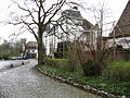
Location of Héron  | |
 Héron Location in Belgium
Location of Héron in the province of Liège  | |
| Coordinates: 50°33′N 05°05′E / 50.550°N 5.083°E | |
| Country | |
| Community | French Community |
| Region | Wallonia |
| Province | Liège |
| Arrondissement | Huy |
| Government | |
| • Mayor | Eric Hautphenne (PSH) |
| • Governing party/ies | PSH, Renouveau |
| Area | |
| • Total | 38.41 km2 (14.83 sq mi) |
| Population (2018-01-01)[1] | |
| • Total | 5,277 |
| • Density | 140/km2 (360/sq mi) |
| Postal codes | 4217, 4218 |
| NIS code | 61028 |
| Area codes | 085 |
| Website | www.heron.be |
Héron is a Walloon municipality located in the Belgian province of Liège and the Huy-Ware district.
Geography
Héron is located on the river Mehaigne.
The municipality consists of the following sub-municipalities: Héron proper, Lavoir, Waret-l'Évêque, and Couthuin.
Demography
On January 1, 2006, Héron had a total population of 4,534. The total area is 38.32 km2 which gives a population density of 118 inhabitants per km2.
Facilities
Heron is home to Couthuin Airport.
Gallery
-
 Saint Hubertus church in Lavoir
 -
 Potesta castle in Envoz
 -
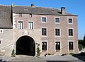 Typical old farm in Héron (17th century).

.jpg)
.jpg)
References
- ^ "Wettelijke Bevolking per gemeente op 1 januari 2018". Statbel. Retrieved 9 March 2019.
External links
 Media related to Héron (Belgium) at Wikimedia Commons
- Official website
Municipalities in the province of Liège, Wallonia | ||
|---|---|---|
| Huy |  | |
| Liège | ||
| Verviers | ||
| Waremme | ||
| ||
This Liège Province location article is a stub. You can help Wikipedia by expanding it. |