
Herzberg (Elster)
Herzberg | |
|---|---|
.png) Coat of arms | |
Location of Herzberg within Elbe-Elster district  | |
 Herzberg  Herzberg | |
| Coordinates: 51°40′59″N 13°13′59″E / 51.68306°N 13.23306°E | |
| Country | Germany |
| State | Brandenburg |
| District | Elbe-Elster |
| Government | |
| • Mayor | Karsten Eule-Prütz |
| Area | |
| • Total | 148.48 km2 (57.33 sq mi) |
| Elevation | 81 m (266 ft) |
| Population (2022-12-31)[1] | |
| • Total | 8,731 |
| • Density | 59/km2 (150/sq mi) |
| Time zone | UTC+01:00 (CET) |
| • Summer (DST) | UTC+02:00 (CEST) |
| Postal codes | 04916 |
| Dialling codes | 03535 |
| Vehicle registration | EE |
| Website | herzberg-elster.de |
Herzberg (Elster) is a town in the Elbe-Elster district of the German federal state of Brandenburg.
Overview
As of 2004, its population is 10,968 and the mayor is Michael Oecknigk of the Christian Democratic Union.

Herzberg (Elster) is twinned with the following cities:
- Büdingen, Hesse
- Świebodzin, Poland
- Dixon, Illinois, United States of America
- Soest, North Rhine-Westphalia
From 1939 to 1945 there was the Deutschlandsender Herzberg/Elster, a huge longwave transmitter, whose mast was the second tallest construction in the world, at Herzberg/Elster. The basement of the mast is still there.

Demography
-
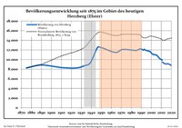 Development of population since 1875 within the current boundaries (Blue line: Population; dotted line: comparison to population development of Brandenburg state; grey background: time of Nazi rule; red background: time of Communist rule)
 -
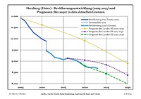 Recent population development (blue line) and forecasts


|
|
|
Sons and daughters of the city

- Louise von François (1817-1893), narrator and writer
- Werner Janensch (1878-1969), paleontologist and geologist
- Steffen Zesner (* 1967), world class swimmer
References
- ^ "Bevölkerungsentwicklung und Bevölkerungsstandim Land Brandenburg Dezember 2022" (PDF). Amt für Statistik Berlin-Brandenburg (in German). June 2023.
- ^ Detailed data sources are to be found in the Wikimedia Commons.Population Projection Brandenburg at Wikimedia Commons
External links
![]() Media related to Herzberg (Elster) at Wikimedia Commons
Media related to Herzberg (Elster) at Wikimedia Commons
Towns and municipalities in Elbe-Elster | ||
|---|---|---|
|  | |
| International | |
|---|---|
| National | |
| Geographic | |
This Brandenburg location article is a stub. You can help Wikipedia by expanding it. |