
Tröbitz
Tröbitz | |
|---|---|
 Coat of arms | |
Location of Tröbitz within Elbe-Elster district 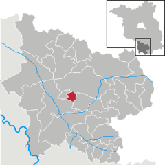 | |
 Tröbitz  Tröbitz | |
| Coordinates: 51°36′00″N 13°25′59″E / 51.60000°N 13.43306°E | |
| Country | Germany |
| State | Brandenburg |
| District | Elbe-Elster |
| Municipal assoc. | Elsterland |
| Government | |
| • Mayor (2024–29) | Holger Gantke[1] (CDU) |
| Area | |
• Total | 10.56 km2 (4.08 sq mi) |
| Elevation | 114 m (374 ft) |
| Population (2022-12-31)[2] | |
• Total | 682 |
| • Density | 65/km2 (170/sq mi) |
| Time zone | UTC+01:00 (CET) |
| • Summer (DST) | UTC+02:00 (CEST) |
| Postal codes | 03253 |
| Dialling codes | 035326 |
| Vehicle registration | EE, FI, LIB |
Tröbitz is a municipality in the Elbe-Elster district, in Lower Lusatia, Brandenburg, Germany.
History
[edit]From 1815 to 1947, Tröbitz was part of the Prussian Province of Brandenburg. From 1952 to 1990, it was part of the Bezirk Cottbus of East Germany.
Demography
[edit]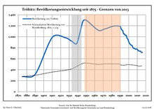
|
|
References
[edit]- ^ Landkreis Elbe-Elster Wahl der Bürgermeisterin / des Bürgermeisters. Retrieved 10 July 2024.
- ^ "Bevölkerungsentwicklung und Bevölkerungsstandim Land Brandenburg Dezember 2022" (PDF). Amt für Statistik Berlin-Brandenburg (in German). June 2023.
- ^ Detailed data sources are to be found in the Wikimedia Commons.Population Projection Brandenburg at Wikimedia Commons
Towns and municipalities in Elbe-Elster | ||
|---|---|---|
|  | |
| International | |
|---|---|
| National | |
| Geographic | |
This Brandenburg location article is a stub. You can help Wikipedia by expanding it. |