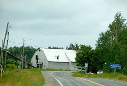
Hilliard, Ontario
Appearance
(Redirected from Hilliardton)
Hilliard | |
|---|---|
| Township of Hilliard | |
 Hilliardton | |
| Coordinates: 47°43′30″N 79°42′00″W / 47.72500°N 79.70000°W | |
| Country | Canada |
| Province | Ontario |
| District | Timiskaming |
| Government | |
| • Type | Township |
| • Reeve | Laurie Bolesworth |
| • Federal riding | Timmins-James Bay |
| • Prov. riding | Timiskaming—Cochrane |
| Area | |
| • Land | 91.38 km2 (35.28 sq mi) |
| Population (2016)[1] | |
• Total | 223 |
| • Density | 2.4/km2 (6/sq mi) |
| Time zone | UTC-5 (EST) |
| • Summer (DST) | UTC-4 (EDT) |
| Postal Code | P0J 1S0 |
| Area code(s) | 705, 249 |
Hilliard is a township in the Canadian province of Ontario, located within the Timiskaming District. Its main community is Hilliardton, located along Secondary Highway 569. The smaller communities of Couttsville and Whitewood Grove are also located within the township.
The township was named in honour of Daniel Hilliard, member of the Legislative Assembly of Ontario from 1886 to 1888.[2]
Demographics
[edit]| Year | Pop. | ±% |
|---|---|---|
| 1991 | 248 | — |
| 1996 | 253 | +2.0% |
| 2001 | 241 | −4.7% |
| 2006 | 222 | −7.9% |
| 2011 | 204 | −8.1% |
| 2016 | 223 | +9.3% |
| [3][4][1] | ||
In the 2021 Census of Population conducted by Statistics Canada, Hilliard had a population of 215 living in 87 of its 93 total private dwellings, a change of 3.9% from its 2016 population of 207. With a land area of 91.27 km2 (35.24 sq mi), it had a population density of 2.4/km2 (6.1/sq mi) in 2021.[5]
Mother tongue:[6]
- English as first language: 75%
- French as first language: 24%
- English and French as first language: 1%
- Other as first language: 0%
See also
[edit]References
[edit]- ^ a b c "Census Profile, 2016 Census: Hilliard, Township". Statistics Canada. 8 February 2017. Retrieved July 17, 2019.
- ^ "ePodunk: Hilliard community profile". Archived from the original on 2012-02-25. Retrieved 2009-07-29.
- ^ Statistics Canada: 1996, 2001, 2006, 2011 census
- ^ 2011 Census Profile
- ^ "Population and dwelling counts: Canada, provinces and territories, census divisions and census subdivisions (municipalities), Ontario". Statistics Canada. February 9, 2022. Retrieved April 2, 2022.
- ^ "2006 Community Profile".


