Jump to content

Hirzenbach

Coordinates: 47°24′16.66″N 8°35′14.31″E / 47.4046278°N 8.5873083°E / 47.4046278; 8.5873083
From Wikipedia, the free encyclopedia

This is an old revision of this page, as edited by SporkBot (talk | contribs) at 03:56, 14 April 2015 (Moving iw-ref to talk page per TfD outcome). The present address (URL) is a permanent link to this revision, which may differ significantly from the current revision.

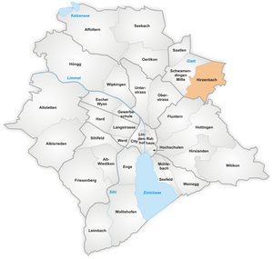
The quarter of Hirzenbach in Zurich
Apartment buildings in Hirzenbach as seen from Sagentobel valley on Adlisberg (April 2010)
Stettbach S-Bahn Zürich train station (December 2009)
Winterthurerstrasse towards Stettbach respectively Dübendorf as seen from Schwamendingen Mitte (December 2009)

Hirzenbach is a quarter in the district 12 of Zurich, located in the Glatt Valley (German: Glattal).

It was formerly a part of Schwamendingen municipality, which was incorporated into Zurich in 1934.

The quarter has a population of 11,265 distributed on an area of 2.62 km².

References

Media related to Hirzenbach at Wikimedia Commons

47°24′16.66″N 8°35′14.31″E / 47.4046278°N 8.5873083°E / 47.4046278; 8.5873083