Ilpendam
Ilpendam | |
|---|---|
 | |
 | |
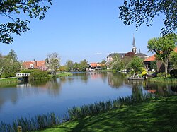
 The village of Ilpendam in the municipality of Waterland. | |
| Coordinates: 52°28′N 4°57′E / 52.467°N 4.950°E | |
| Country | Netherlands |
| Province | |
| Municipality | Waterland |
| Area | |
| • Total | 2.46 km2 (0.95 sq mi) |
| Population (2008) | |
| • Total | 1,780 |
| • Density | 720/km2 (1,900/sq mi) |
| Time zone | UTC+1 (CET) |
| • Summer (DST) | UTC+2 (CEST) |
Ilpendam is a town in the province of North Holland, Netherlands. It is a part of the municipality of Waterland, and lies about 4 km south of Purmerend. It covers an area of 2.46 km2 (0.95 sq mi) and had 1,780 inhabitants in 2008.
History
The man standing highlighted at center on Rembrandts Night Watch painting is Frans Banning Cocq. He was Mayor of Amsterdam, Lord of Purmerland and Ilpendam and Lord of Ilpenstein castle.
Ilpendam was a separate municipality until 1991.[1]
In 2001, the town of Ilpendam had 1,613 inhabitants. The built-up area of the village was 0.27 km², and contained 633 residences.[2] The wider statistical area of Ilpendam has a population of around 1850.[3]
Until 1872 there was a castle, called Ilpenstein, of the Lordship of Purmerland and Ilpendam.
Notable persons of Ilpendam
- Mona Keijzer (born 1968), politician
See also
References
- ^ Ad van der Meer and Onno Boonstra, "Repertorium van Nederlandse gemeenten", KNAW, 2006. knap.nl.
- ^ Statistics Netherlands (CBS), Bevolkingskernen in Nederland 2001 "Archived copy". Archived from the original on March 19, 2006. Retrieved January 24, 2007.
{{cite web}}: Unknown parameter|deadurl=ignored (|url-status=suggested) (help)CS1 maint: archived copy as title (link). Statistics are for the continuous built-up area. - ^ Statistics Netherlands (CBS), Gemeente Op Maat 2004: Waterland [1][permanent dead link].
External links
- Template:Kuyper Map of the former municipality in 1868.

