Ivankiv
Ivankiv
Іванків | |
|---|---|
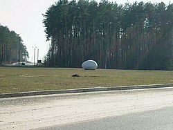
 "Big Egg" monument near Ivankiv's bus station | |
| Coordinates: 50°56′00″N 29°54′0″E / 50.93333°N 29.90000°E | |
| Country | |
| Oblast | |
| Raion | |
| Founded | 1589 |
| Area | |
| • Total | 8 km2 (3 sq mi) |
| Population (2001) | |
| • Total | 10,563 |
| Postal code | 07200 |
| Area code | +380 4491 |
| Website | Official website |
Ivankiv (Ukrainian: Іва́нків [iˈβɑnkiu̯]; Russian: Ива́нков, romanized: Ivankov [ɪˈvankəf]) is an urban-type settlement in Kiev Oblast (province) of Ukraine. It is situated on the left bank of the Teteriv River. It is the administrative center of Ivankiv Raion, and its population was 10,625 (2013 est.)[1]. In 2001, the population had been 10,563.
History

In the middle of the 15th century, the territory around modern Ivankiv was called "Zemlya Trudinivska" (Trudinivska Land). It was a property of Kiev boyar Olehnja Juhnovich. In 1524 King of Poland Sigismund I the Old gave this land to Kiev Burgess Tishko Proskura.[2] In 1589 Ivan Proskura became the owner of this land. The town was founded in 1589 and named after Ivan Proskura. At first it was called "Ivaniv" and "Ivanivka" but later changed to "Ivankiv".[3] At the beginning of the 17th century, Crimean Tatars made four military campaigns on Polesia, and as a result, many people in Ivankiv were killed, taken prisoner and sold into slavery.
On 30 May 1645, the forces of Grand Crown Hetman Stanisław Koniecpolski attacked Ivankiv, which at that time belonged to Olizar Wołczkiewicz.
Geography
Located in the middle of the southern area of its raion, Ivankiv lies between Kiev and Pripyat. It is located 42 miles (68 km) south from the Chernobyl power plant, with the entrance to the exclusion zone being located 20 miles (32 km) north, at Dytiatky. Ivankiv town was not as affected by the Chernobyl disaster compared to other towns.
Notable residents
- Mykola Dzydzora (b. 1975), diplomatic
- Valentyn Feshenko (b. 1936), film director
See also
References
- ^ Чисельність наявного населення України [Actual population of Ukraine] (in Ukrainian). State Statistics Service of Ukraine. Archived from the original on 2014-02-02. Retrieved 21 January 2015.
- ^ Template:Uk icon Ivankiv on imsu-kyiv.com
- ^ Ivankiv (Toponymic Dictionary) Archived 2013-09-29 at the Wayback Machine


