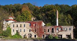
Jordan Brewery Ruins
Appearance
Jordan Brewery Ruins | |
 The Jordan Brewery Ruins in autumn 2015 | |
| Location | 415 Broadway Street South, Jordan, Minnesota |
|---|---|
| Coordinates | 44°39′48″N 93°37′31″W / 44.66333°N 93.62528°W |
| Built | 1864 |
| Architect | Unknown |
| Architectural style | No Style Listed |
| MPS | Scott County MRA |
| NRHP reference No. | 80002162[1] |
| Added to NRHP | April 17, 1980 |
The Jordan Brewery Ruins include a complex of limestone buildings built between 1861 and 1900 by brewer Frank Nicolin. It is listed on the National Register of Historic Places in Jordan, Minnesota, United States.[2]
A microbrewery was planned to open in the complex in 2014, but a mudslide triggered by heavy rains damaged the complex and has left its future use in doubt.[3]
References
- ^ "National Register Information System". National Register of Historic Places. National Park Service. January 23, 2007.
- ^ Nord, Mary Ann (2003). The National Register of Historic Places in Minnesota. Minnesota Historical Society. ISBN 0-87351-448-3.
- ^ Adler, Erin (29 June 2015). "Jordan Brewery plans still buried a year after mudslide". Minneapolis Star-Tribune.
External links
Categories:
- Buildings and structures in Scott County, Minnesota
- Defunct brewery companies of the United States
- Industrial buildings and structures on the National Register of Historic Places in Minnesota
- Ruins in the United States
- National Register of Historic Places in Scott County, Minnesota
- Minnesota Registered Historic Place stubs


