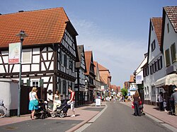
Kandel
Appearance
Kandel | |
|---|---|
 Town centre | |
Location of Kandel within Germersheim district  | |
| Country | Germany |
| State | Rhineland-Palatinate |
| District | Germersheim |
| Municipal assoc. | Kandel |
| Subdivisions | 3 |
| Government | |
| • Mayor | Günther Tielebörger (SPD) |
| Area | |
| • Total | 26.64 km2 (10.29 sq mi) |
| Elevation | 123 m (404 ft) |
| Population (2022-12-31)[1] | |
| • Total | 9,212 |
| • Density | 350/km2 (900/sq mi) |
| Time zone | UTC+01:00 (CET) |
| • Summer (DST) | UTC+02:00 (CEST) |
| Postal codes | 76870 |
| Dialling codes | 07275 |
| Vehicle registration | GER |
| Website | www.kandel.de |
Kandel is a town in the Germersheim district of Rhineland-Palatinate, Germany, near the border with France and approximately 18 km north-west of Karlsruhe, and 15 km south-east of Landau.
Kandel is twinned with the small Lancashire town of Whitworth.
Kandel is the seat of the Verbandsgemeinde ("collective municipality") Kandel.
-
St Georg
-
The Dampfnudeltor
-
House in Kandel
-
Station
Coat of arms meaning
Star: Celestial goodness, noble person, leadership, excellence.
Sword: Justice and military honour.
Sky-Blue (Azure): Truth and loyalty.
References
- ^ "Bevölkerungsstand 2022, Kreise, Gemeinden, Verbandsgemeinden" (PDF) (in German). Statistisches Landesamt Rheinland-Pfalz. 2023.


