
Kaptai Lake
| Kaptai Lake | |
|---|---|
 | |
| Location | South-Eastern Bangladesh |
| Coordinates | 22°29′45″N 92°13′45″E / 22.49583°N 92.22917°E |
| Type | reservoir |
| Primary inflows | Karnaphuli River |
| Primary outflows | Karnaphuli River |
| Catchment area | 11,122 km2 (4,294 sq mi) [original research?] |
| Basin countries | Bangladesh |
| Average depth | 100 ft (30 m) |
| Max. depth | 495 ft (151 m) |
Kaptai Lake is the largest man made lake in Bangladesh.[1] It is located in the Kaptai Upazila under Rangamati District of Chittagong Division. The lake was created as a result of building the Kaptai Dam on the Karnaphuli River, as part of the Karnaphuli Hydro-electric project. The Kaptai Lake's average depth is 100 feet (30 m) and maximum depth is 490 feet (150 m).
History
Construction of the reservoir for the hydro-electric plant began in 1956 by the Government of East Pakistan.[2] As a result, 54,000 acres (220 km2) of farmland in the Rangamati District went under water and created the lake. The hydro-electric project was funded by the United States. The project was finished in 1962. International Engineering Company and Utah International Inc. received the contract for construction of the dam. The dam is 670.8 meters long, and 54.7 meters high. The dam has a 745 feet (227 m) long spillway containing 16 gates. Through the spillway 5,250,000 cu ft/s (149,000 m3/s) of water can pass.

The land that went under water as a result of the dam construction, was 40% of the total arable land in the area. Along with that, 29 square miles (75 km2) of the Government-owned forest, and 234 square miles (610 km2) of other forest land went under water. About 18,000 families with a total of almost 100 thousand people were also displaced. The palace of the king of the Chakmas was also flooded and is now under water.[2]
Ecological disaster
The ecological damage of the lake recently assessed shows that water pollution due to the use of fertilisers and pesticides around the lake is affecting life in the water. In 1966, the share of big fishes in the total fish production was 78%, by 1993 it had come down to 2%. Also, more than five tons of human excrements and other wastes are reported to flow into the lake every day. As 85% of the population living around the lake depends on the water for drinking, cooking, washing and bathing, health risks have increased sharply.
Gallery
-
 Hanging Bridge
 -
 the lake
 -
 Sunset on the lake
 -
 Bridge over the lake
 -
 Boat on the lake
 -
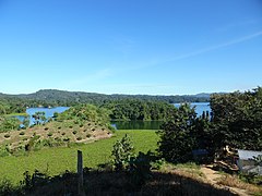 View of Kaptai lake, Rangamati
 -
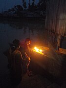 Prayer at Kaptai Lake


See also
References
- ^ "Kaptai Lake - Banglapedia". en.banglapedia.org. Retrieved 2016-04-16.
- ^ a b Daily JaiJaiDin, January 10, 2008. Page 10.
This Chittagong Division location article is a stub. You can help Wikipedia by expanding it. |