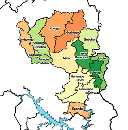
Karaga District
Karaga District | |
|---|---|
 Districts of Northern region | |
Karaga District in Northern region | |
| Coordinates: 9°48′N 0°30′W / 9.800°N 0.500°W | |
| Region | Northern Region |
| Capital | Karaga |
| Government | |
| • District executive | Mohammed Abdulai Sandow |
| Population (2013) | |
| • Total | — |
| Time zone | UTC+0 (Greenwich Mean Time) |
| • Summer (DST) | GMT |
| ISO 3166 code | GH-NP-KA |
The Karaga District is one of the twenty (20) districts in the Northern Region of north Ghana.[1] The capital is Karaga.
Boundaries
Karaga district's western neighbour is Savelugu-Nanton District. To the north are West Mamprusi District and the East Mamprusi District. To the south and east is the Gushiegu District from which Karaga district was carved.[2]


