
Kijong-dong
| Kijong-dong | |
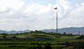
 The Kijŏngdong flagpole, flying the DPRK flag. | |
| Korean name | |
|---|---|
| Chosŏn'gŭl | 기정동 |
| Hancha | |
| Revised Romanization | Gijeongdong |
| McCune–Reischauer | Kijŏngdong |

Kijŏngdong, Kijŏng-dong or Kijŏng tong is a village in P'yŏnghwa-ri (Korean: 평화리; Hancha: 平和里),[1] Kaesong-si,[2] North Korea. It is situated in the North's half of the Korean Demilitarized Zone (DMZ).[3] Also known in North Korea as Peace Village (Korean: 평화촌; Hancha: 平和村; MR: p'yŏnghwach'on; ),[4] it has been widely referred to as Propaganda Village by those outside North Korea, especially in Western and South Korean media (Korean: 선전마을; Hanja: 宣傳마을; RR: seonjeon maeul).[5][6][7][8][3] Kijŏngdong is one of two villages permitted to remain in the 4-kilometer-wide (2.5 mi) DMZ set up under the 1953 armistice suspending the Korean War;[7][9] the other is the South Korean village of Daeseong-dong,[9] 2.22 kilometers (1.38 mi) away.
History
The official position of the North Korean government is that the village contains a 200-family collective farm, serviced by a childcare center, kindergarten, primary and secondary schools, and a hospital.[10] However, observation from the South suggests that the town is actually an uninhabited Potemkin village built at great expense in the 1950s in a propaganda effort to encourage South Korean defection and to house the PRK soldiers manning the extensive network of artillery positions, fortifications and underground marshalling bunkers that abut the border zone.[3][4][11][12] Though no visitors are allowed, it is the only settlement in North Korea within direct eye- and earshot of the Korean DMZ.
The village features a number of brightly painted, poured-concrete multi-story buildings and apartments, many apparently wired for electricity – these amenities represent an unheard-of level of luxury for any rural Korean in the 1950s, north or south. The town was oriented so that the bright blue roofs and white sides of the buildings next to the massive DPRK flag would be the most distinguishing features when viewed from across the border. Scrutiny with modern telescopic lenses, however, reveals that the buildings are mere concrete shells lacking window glass or even interior rooms,[11][13] with building lights turned on and off at set times and empty sidewalks swept by a skeleton crew of caretakers in an effort to preserve the illusion of activity.[14]
Until 2004, massive loudspeakers mounted on several of the buildings continuously delivered DPRK propaganda broadcasts directed towards the south.[11] Originally the content consisted of extolling the North's virtues in great detail and urging disgruntled soldiers and farmers to simply walk across the border to be received as brothers.[15] Eventually, as its value in inducing defections proved minimal[16], the content was switched to blaring, condemnatory anti-Western propaganda speeches, Communist agitprop operas, and patriotic marching music at high volume for up to 20 hours a day.[17]
In 1980s, the South Korean government built a 98.4 m (323 ft) tall flagpole with a 130-kilogram (287 lb) flag of South Korea in Daeseong-dong. The North Korean government responded by building a taller one at 160 m (525 ft) with a 270 kg (595 lb) flag of North Korea in Kijŏng-dong, only 1.2 km (0.7 mi) west of the border with the South Korea, in what some have called the "flagpole war". The flagpole was the second tallest in the world at present, after the flag of Azerbaijan in Baku at 162 m (531 ft).[11][18][19][20] Both flagpoles have recently been topped by the Dushanbe Flagpole in Tajikistan, at 165 m (541 ft).
Gallery
-
 View of Kijŏngdong
 -
 View of Kijŏngdong
 -
 A wide view of Kijŏngdong with prominent flag pole


See also
References
- ^ a b "기정동(機井洞)[트느피마을, 틀늪]". 북한지역정보넷 (North Korean Human geography) (in Korean). Galhyeon-dong, Seoul: 평화문제연구소. 2007-12-08?. Retrieved 2010-04-11.
{{cite web}}: Check date values in:|date=(help) - ^ P'yŏnghwa-ri belonged to P'anmun-gun (Korean: 판문군; Hancha: 板門郡) until the creation of Kaesong Industrial Region in November 2002, when P'anmun-gun was dissolved and its territory divided among Kaesong, Changp'ung-gun and Kaep'ung-gun. P'yŏnghwa-ri joined Kaesong.
- ^ a b c Tran, Mark (2008-06-06). "Travelling into Korea's demilitarised zone: Run DMZ". The Guardian. London: Guardian Media Group. Retrieved 2009-07-05.
Kijong-dong was built specially in the north area of DMZ. Designed to show the superiority of the communist model, it has no residents except soldiers.
- ^ a b Kijungdong, North Korea's Propaganda Village November 12, 2006 http://www.panmunjomtour.com/english/jsa/jsa_16.htm
- ^ Korean Demilitarized Zone - Globalsecurity.org http://www.globalsecurity.org/military/facility/dmz.htm
- ^ Template:Ko icon "북한의 기정동 선전마을". TourDMZ.com. Retrieved 2006-10-09.
- ^ a b Kozaryn, Linda D. (1997-04-14). "Cohen: Economic Failure Plagues North Korea". DefenseLink. U.S. Department of Defense. American Forces Press Service. Retrieved 2009-07-05.
{{cite news}}: External link in|work= - ^ Mansfield, Paul (1997-06-22). "'This is Freedom Village,' said Sgt Manfull". The Independent. London: Independent News & Media. Retrieved 2009-07-05.
- ^ a b Flack, T.D. (2008-02-19). "DMZ sixth-graders become graduates". Stars and Stripes, Pacific Edition. Tokyo. Retrieved 2009-07-05.
- ^ A Sightseeng Guide to Korea by Pang hwon Ju & Hwang Bong Hyok, Foreign Languages Publishing House, Pyongyang, DPRK. 1991
- ^ a b c d Potts, Rolf. Korea's No-Man's-Land. Salon, February 3, 1999
- ^ Sullivan, Kevin. Borderline Absurdity: A Fun-Filled Tour of the Korean DMZ. Washington Post Foreign Service, January 11, 1998.
- ^ O'Neill, Tom. "Korea's DMZ: Dangerous Divide". National Geographic, July 2003.
- ^ Silpasornprasit, Susan. "Day trip to the DMZ: A look inside the Korean Demilitarized Zone". IMCOM-Korea Region Public Affairs Office, US Army. <http://imcom.korea.army.mil/imakoroweb/sites/local/news/020808_IMCOMK_DMZ.asp> Retrieved 30 JAN 09.
- ^ http://dailypropaganda.com/2011/05/06/kijong-dong-north-korea/
- ^ http://upandgone.wordpress.com/2011/05/07/top-10-crazy-facts-about-kim-jong-il/
- ^ http://dailypropaganda.com/2011/05/06/kijong-dong-north-korea/
- ^ Korea's DMZ: Scariest place on Earth February 20, 2002 http://edition.cnn.com/2002/WORLD/asiapcf/east/02/19/koreas.dmz/
- ^ "CNN.com - Korea's DMZ: 'Scariest place on Earth' - February 20, 2002". 2002-02-20. Retrieved 2007-10-23.
- ^ Template:Ko icon "개성에 '구멍탄' 5만장 배달했습니다". economy.ohmynews.com. Retrieved 2006-12-06.