
Kościan
Kościan | |
|---|---|
 City Hall | |
 Flag  Coat of arms | |
| Country | |
| Voivodeship | Greater Poland |
| County | Kościan County |
| Gmina | Kościan (urban gmina) |
| Established | 12th century |
| Town rights | 13th century |
| Government | |
| • Mayor | Michał Jurga |
| Area | |
| • Total | 8.75 km2 (3.38 sq mi) |
| Highest elevation | 85 m (279 ft) |
| Lowest elevation | 75 m (246 ft) |
| Population (2014) | |
| • Total | 23,952 |
| • Density | 2,700/km2 (7,100/sq mi) |
| Time zone | UTC+1 (CET) |
| • Summer (DST) | UTC+2 (CEST) |
| Postal code | 64-000 |
| Area code | +48 65 |
| Car plates | PKS |
| Website | http://www.koscian.pl |
Kościan [ˈkɔɕt͡ɕan] (German: Kosten) is a town on the Obra canal in west-central Poland, with a population of 23 952 inhabitants as of June 2014.[1] Situated in the Greater Poland Voivodeship (since 1999), previously in Leszno Voivodeship (1975–1998), it is the capital of Kościan County. Polish nobleman Ignacy Wyssogota Zakrzewski was born nearby.
Notable people from Kościan
- Dezydery Chłapowski (1788–1879)
- Klemens Koehler (1840–1901)
- Józef Surzyński (1851–1919)
- Piotr Bresiński (1870–1940)
- Feliks Stamm (1901–1976)
- Izabella Zielińska (1910)
- Zenon Brudkiewicz (1913–1940)
- Henryk Florkowski (1921–2003)
- Rafał Bryndal (1960)
- Jarosław Jaromi Drażewski (1961)
- Waldemar Brygier (1970)
- Bartosz Jurecki (1979)
- Michał Jurecki (1984)
- Krystian Klecha (1984)
- Tomasz Nowak (1985)
- Zofia Nowakowska (1988)
International relations
Twin towns – Sister cities
Kościan is twinned with:
|
|
Old buildings
-
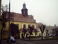 Christ Church built in 1666
 -
 Bent house at Masztalerza Street
 -
 Medieval wall


External links
Wikimedia Commons has media related to Kościan.
References
52°05′N 16°39′E / 52.083°N 16.650°E
Seat: Kościan (urban gmina) | ||
| Urban-rural gminas |  | |
| Rural gmina | ||

| International | |
|---|---|
| National | |
| Geographic | |
This Greater Poland Voivodeship location article is a stub. You can help Wikipedia by expanding it. |