
Kōpuaranga
Kōpuaranga | |
|---|---|
Locality | |
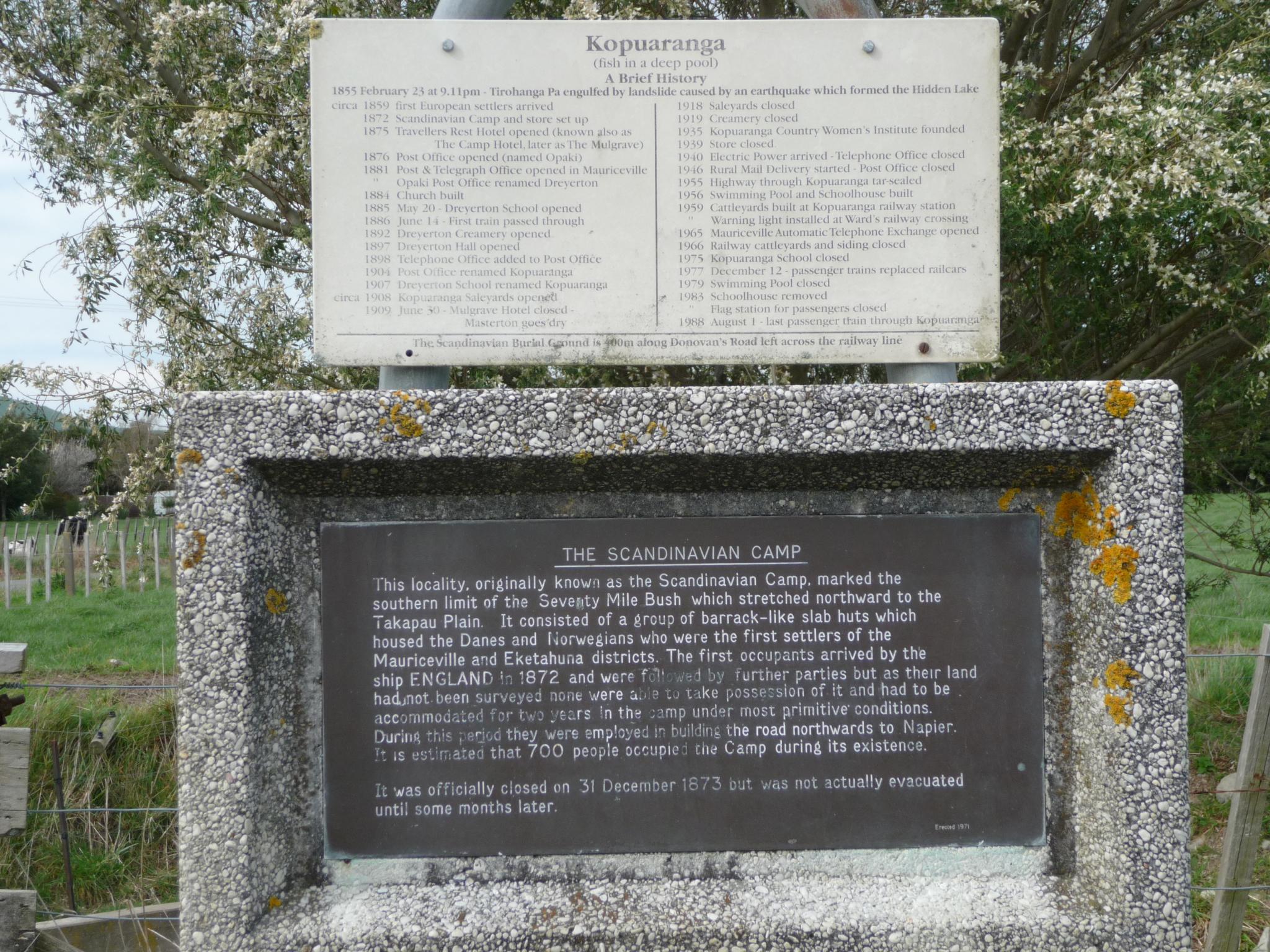
.jpg) Scandinavian camp memorial | |
 | |
| Coordinates: 40°50′S 175°40′E / 40.833°S 175.667°E | |
| Country | |
| Region | Wellington Region |
| Territorial authority | Masterton District |
| Ward |
|
| Electorates | |
| Government | |
| • Territorial Authority | Masterton District Council |
| • Regional council | Greater Wellington Regional Council |
| • Mayor of Masterton | Gary Caffell |
| • Wairarapa MP | Mike Butterick |
| • Ikaroa-Rāwhiti MP | Cushla Tangaere-Manuel |
| Area | |
| • Total | 458.04 km2 (176.85 sq mi) |
| Population (June 2023)[2] | |
| • Total | 1,090 |
| • Density | 2.4/km2 (6.2/sq mi) |
Kōpuaranga, until 1906 called Dreyerton, is a rural locality[3] in the Wairarapa region of New Zealand's North Island, between Masterton and Mauriceville.
Etymology[edit]
The name Kōpuaranga comes from Māori words meaning 'deep hole' and 'shoal of fish'.[4]
History[edit]
The area was a temporary camp used by Scandinavians who had been brought in to clear and settle the Seventy Mile Bush, but could not take up their allotted land until it had been surveyed, and the area was thus known simply as The Camp[4] or The Scandinavian Camp,[5] the camp was officially closed on 31 December 1873, and an estimated 700 people had occupied the camp during its existence.
In 1876 a Post Office was opened, named Opaki, however the settlement's name was changed to Dreyerton[6] in 1881,[5] after Danish interpreter Alexander Svend Dreyer,[6] who had accompanied the pioneers and conceived the idea for a township.[7]
Dreyerton school was founded in 1885, and in 1897 the school had an average attendance of about forty.[8] One amusing incident during the school's history was the school committee election of 1889, which fell through when only the committee members arrived, and refused to vote for themselves.[7] The school was closed in 1975.
The name was changed to Kopuaranga in 1906, after the government assigned railway stations Māori language names. The Wellington Education Board then changed the name of the local school to match the station,[7] and the name of the settlement changed also. Kopuaranga railway station eventually closed in 1983. In December 2019, the approved official geographic name of the locality was gazetted as "Kōpuaranga".[9]
Demographics[edit]
Kōpuaranga statistical area covers 458.04 km2 (176.85 sq mi).[1] It had an estimated population of 1,090 as of June 2023,[2] with a population density of 2.4 people per km2.
| Year | Pop. | ±% p.a. |
|---|---|---|
| 2006 | 771 | — |
| 2013 | 855 | +1.49% |
| 2018 | 915 | +1.37% |
| Source: [10] | ||

Kōpuaranga had a population of 915 at the 2018 New Zealand census, an increase of 60 people (7.0%) since the 2013 census, and an increase of 144 people (18.7%) since the 2006 census. There were 348 households, comprising 459 males and 456 females, giving a sex ratio of 1.01 males per female. The median age was 45.3 years (compared with 37.4 years nationally), with 177 people (19.3%) aged under 15 years, 126 (13.8%) aged 15 to 29, 453 (49.5%) aged 30 to 64, and 159 (17.4%) aged 65 or older.
Ethnicities were 91.8% European/Pākehā, 10.2% Māori, 1.3% Pasifika, 2.3% Asian, and 2.6% other ethnicities. People may identify with more than one ethnicity.
The percentage of people born overseas was 15.4, compared with 27.1% nationally.
Although some people chose not to answer the census's question about religious affiliation, 56.1% had no religion, 33.4% were Christian, 0.7% were Buddhist and 1.6% had other religions.
Of those at least 15 years old, 153 (20.7%) people had a bachelor's or higher degree, and 126 (17.1%) people had no formal qualifications. The median income was $35,400, compared with $31,800 nationally. 129 people (17.5%) earned over $70,000 compared to 17.2% nationally. The employment status of those at least 15 was that 390 (52.8%) people were employed full-time, 153 (20.7%) were part-time, and 12 (1.6%) were unemployed.[10]
References[edit]
- ^ a b "ArcGIS Web Application". statsnz.maps.arcgis.com. Retrieved 12 January 2024.
- ^ a b "Population estimate tables - NZ.Stat". Statistics New Zealand. Retrieved 25 October 2023.
- ^ "Place name detail: Kōpuaranga". New Zealand Gazetteer. New Zealand Geographic Board. Retrieved 23 June 2018.
- ^ a b "About the profile areas - Kopuaranga - profile.id". Profile.idnz.co.nz.
- ^ a b "Photographic image of camp sign" (JPG). Farm4.static.flickr.com. Retrieved 5 August 2018.
- ^ a b "Masterton District- Registered Heritage Items (NZHPT Registration includes the whole premises) : Awamaru, 20 McKenna Street (RC II)" (PDF). Mstn.govt.nz. Retrieved 5 August 2018.
- ^ a b c "Dreyerton/Kopuaranga School" (PDF). Wairarapaschoolhistory.co.nz. Retrieved 5 August 2018.
- ^ "Dreyerton - NZETC". Nzetc.victoria.ac.nz.
- ^ "NZGB notices – December 2019". Land Information New Zealand. 10 December 2019. Retrieved 15 December 2019.
- ^ a b "Statistical area 1 dataset for 2018 Census". Statistics New Zealand. March 2020. Kopuaranga (255300). 2018 Census place summary: Kopuaranga