
Korean Demilitarized Zone
| Korean Demilitarized Zone (DMZ) | |
|---|---|
| Korean Peninsula | |
 The Korean DMZ is shown in red with the Military Demarcation Line (MDL) denoted by the black line. | |
| Type | DMZ |
| Site information | |
| Controlled by | |
| Open to the public | No, access only by permission |
| Condition | Fully manned and operational |
| Site history | |
| Built by | |
| In use | July 27, 1953, onwards |
| Events | Division of Korea |

The Korean Demilitarized Zone (DMZ; Korean: 한반도 비무장지대; Hanja: 韓半島非武裝地帶) is a strip of land running across the Korean Peninsula; it was established at the end of the Korean War to serve as a buffer zone between North and South Korea. The DMZ is a de facto border barrier that cuts the Korean Peninsula roughly in half, crossing the 38th parallel north on an angle, with the west end of the DMZ lying south of the parallel and the east end lying north of it. It was created as part of the Korean Armistice Agreement between North Korea, the People's Republic of China, and the United Nations Command forces in 1953.
It is 250 kilometres (160 miles) long,[1] approximately 4 km (2.5 mi) wide and, despite its name, is the most heavily militarized border in the world.[2][3] The Northern Limit Line, or NLL, is the disputed maritime demarcation line between North and South Korea in the Yellow Sea, not agreed in the armistice. The coastline and islands on both sides of the NLL are also heavily militarized.[4]
History
The 38th parallel north—which divides the Korean Peninsula roughly in half—was the original boundary between the United States and Soviet brief administration areas of Korea at the end of World War II. Upon the creation of the Democratic People's Republic of Korea (DPRK, informally North Korea) and the Republic of Korea (ROK, informally South Korea) in 1948, it became a de facto international border and one of the most tense fronts in the Cold War.
Both the North and the South remained heavily dependent on their sponsor states from 1948 to the outbreak of the Korean War. The conflict, which claimed over three million lives and divided the Korean Peninsula along ideological lines, commenced on June 25, 1950, with a full-front DPRK invasion across the 38th parallel, and ended in 1953 after international intervention pushed the front of the war back to near the 38th parallel.

In the Armistice Agreement of July 27, 1953, the DMZ was created as each side agreed to move their troops back 2,000 m (2,200 yards) from the front line, creating a buffer zone 4 km (2.5 mi) wide. The Military Demarcation Line (MDL) goes down the center of the DMZ and indicates exactly where the front was when the agreement was signed.
Owing to this theoretical stalemate, and genuine hostility between the North and the South, large numbers of troops are still stationed along both sides of the line, each side guarding against potential aggression from the other side. The armistice agreement explains exactly how many military personnel and what kind of weapons are allowed in the DMZ. Soldiers from both sides may patrol inside the DMZ, but they may not cross the MDL. Sporadic outbreaks of violence have killed over 500 South Korean soldiers, 50 U.S. soldiers and 250 soldiers from DPRK along the DMZ between 1953 and 1999.[5]
Daeseong-dong (also written Tae Sung Dong) and Kijŏng-dong were the only villages allowed by the armistice committee to remain within the boundaries of the DMZ.[6] Residents of Tae Sung Dong are governed and protected by the United Nations Command and are generally required to spend at least 240 nights per year in the village to maintain their residency.[6] In 2008, the village had a population of 218 people.[6] The villagers of Tae Sung Dong are direct descendants of people who owned the land before the 1950–53 Korean War.[7]
To continue to deter North Korean incursion, in 2014 the United States government exempted the Korean DMZ from its pledge to eliminate anti-personnel landmines.[8]
Joint Security Area


Inside the DMZ, near the western coast of the peninsula, Panmunjom is the home of the Joint Security Area (JSA). Originally, it was the only connection between North and South Korea[9] but that changed in 2007 when a Korail train crossed the DMZ to the North on the new Donghae Bukbu Line built on the east coast of Korea.
There are several buildings on both the north and the south side of the Military Demarcation Line (MDL), and there have been some built on top of it. The JSA is the location where all negotiations since 1953 have been held, including statements of Korean solidarity, which have generally amounted to little except a slight decline of tensions. The MDL goes through the conference rooms and down the middle of the conference tables where the North Koreans and the United Nations Command (primarily South Koreans and Americans) meet face to face.
Within the JSA are a number of buildings for joint meetings called Conference Row. These are used for direct talks between the Korean War participants and parties to the armistice. Facing the Conference Row buildings are the North Korean Panmungak (English: Panmun Hall) and the South Korean Freedom House. In 1994, North Korea enlarged Panmungak by adding a third floor. In 1998, South Korea built a new Freedom House for its Red Cross staff and to possibly host reunions of families separated by the Korean War. The new building incorporated the old Freedom House Pagoda within its design.
Since 1953 there have been occasional confrontations and skirmishes within the JSA. The Axe Murder Incident in August 1976 involved the attempted trimming of a tree which resulted in two deaths (CPT Arthur Bonifas and 1LT Mark Barrett). Another incident occurred on November 23, 1984, when a Soviet tourist Vasily Matuzok (sometimes spelled Matusak), who was part of an official trip to the JSA (hosted by the North), ran across the MDL shouting that he wanted to defect.[10] North Korean troops immediately chased after him opening fire. Border guards on the South Korean side returned fire eventually surrounding the North Koreans as they pursued Matusak. One South Korean and three North Korean soldiers were killed in the action, and Matusak was not captured.[11]
In late 2009, South Korean forces in conjunction with the United Nations Command began renovation of its three guard posts and two checkpoint buildings within the JSA compound. Construction was designed to enlarge and modernize the structures. Work was undertaken a year after North Korea finished replacing four JSA guard posts on its side of the MDL.[12]
It has been suggested that this section be merged into List of border incidents involving North Korea. (Discuss) Proposed since August 2015. |

Since demarcation, the DMZ has had numerous cases of incidents and incursions by the North Koreans, although the North Korean government never acknowledges direct responsibility for any of these incidents.[13] These include:
- October 1966–October 1969: The Korean DMZ Conflict, a series of skirmishes along the DMZ, results in 43 American, 299 South Korean and 397 North Korean soldiers killed.[14]
- January 17, 1968: 31 North Korean commandos crossed the border disguised as South Korean soldiers in the Blue House Raid, an attempt to assassinate President Park Chung Hee at the Blue House. The failed mission resulted in 29 commandos killed (one committed suicide), one captured and one escaped. Two South Korean policemen and five civilians were killed by the commandos. Other reports indicated as many as 68 South Koreans were killed and 66 wounded, including about 24 civilians. Three Americans were killed and another three wounded in an attempt to prevent the commandos from escaping back via the DMZ.[15]
- October 1968: 130 North Korean commandos entered the Ulchin and Samcheok areas in Gangwon-do. Eventually 110 of them were killed, 7 captured, and 13 escaped.
- March 1969: Six North Korean infiltrators crossed the border near Chumunjin, Gangwon-do and killed a South Korean policeman on guard duty.
- April 1970: Three North Korean infiltrators were killed and five South Korean soldiers wounded at an encounter in Kumchon, Gyeonggi-do.
- November 20, 1974: The first of what would be a series of North Korean infiltration tunnels under the DMZ was discovered. The joint ROK-U.S. investigation team tripped a North Korean booby-trap, killing one American and wounding 6 others.
- March 1975: The second North Korean infiltration tunnel was discovered.
- June 1976: Three North Korean infiltrators and six South Korean soldiers were killed in the eastern sector south of the DMZ. Another six South Korean soldiers were injured.
- August 18, 1976: The axe murder incident resulted in the death of two U.S. soldiers and injuries to another four U.S. soldiers and five South Korean soldiers.
- July 14, 1977: An American CH-47 Chinook helicopter was shot down after straying into the north over the DMZ. Three airmen were killed and one was briefly held prisoner (this was the sixth such incident since the armistice was signed).[16]
- October 1978: The third North Korean infiltration tunnel was discovered.
- October 1979: Three North Korean agents attempting to infiltrate the eastern sector of the DMZ were intercepted, killing one of the agents.
- December 6, 1979: US patrol in the DMZ accidentally crossed the MDL into a North Korean minefield. One US soldier was killed and four were injured.[17]
- March 1980: Three North Korean infiltrators were killed attempting to enter the south across the estuary of the Han River.
- March 1981: Three North Korean infiltrators spotted at Kumhwa, Gangwon-do, with one being killed.
- July 1981: Three North Korean infiltrators were killed in the upper stream of Imjin River.
- May 1982: Two North Korean infiltrators were spotted on the east coast, with one being killed.
- March 1990: The fourth North Korean infiltration tunnel was discovered, in what may be a total of 17 tunnels in all.
- May 1992: Three North Korean infiltrators dressed in South Korean uniforms were killed at Cheorwon, Gangwon-do. Three South Koreans were also wounded.
- December 17, 1994: An American OH-58A+ Kiowa helicopter crosses 10 km into North Korean territory and was shot down. Of the crew of two, one died and the other was held for 13 days.[17]
- October 1995: Two North Korean infiltrators were intercepted at Imjin River. One was killed, while the other escaped.
- April 1996: Several hundred North Korean armed troops enter the Joint Security Area and elsewhere on three occasions, in violation of the Korean armistice agreement.
- May 1996: Seven North Korean soldiers crossed the DMZ, but withdrew when fired upon by South Korean troops.
- April 1997: Five North Korean soldiers crossed the military demarcation line's in the Cheorwon sector and fired at South Korean positions.
- July 16, 1997: Fourteen North Korean soldiers crossed the MDL, causing a half-hour exchange of heavy gunfire.[18]
- October 26, 2000: Two US aircraft observing a ROK army military exercise accidentally crossed over the DMZ.[17]
- May 26, 2006: Two North Korean soldiers entered the DMZ and crossed into South Korea. They returned after South Korean soldiers fired warning shots.
- October 7, 2006: South Korean soldiers fired warning shots after five North Korean soldiers crossed briefly into their side of the border.
- October 27, 2009: A South Korean pig farmer, who was wanted for assault, cut a hole in the DMZ fence and defected to North Korea.[19]
- October 29, 2010: Two shots were fired from North Korea toward a South Korean post near Hwacheon and South Korean troops fired three shots in return.[20]
- October 6, 2012: An 18-year-old North Korean Army private defected to South Korea. He was apparently not detected as he crossed the DMZ and had to knock on an ROK barracks door to draw attention to himself. The soldier later told investigators that he had defected after killing two of his superiors.[21][22]
- September 16, 2013: A 47-year-old man was shot dead by South Korean soldiers while trying to swim across the Tanpocheon Stream near Paju to North Korea.[23]
- March 24, 2014: A North Korean drone was found crashed near Paju, the onboard cameras contained pictures of the Blue House and military installations near the DMZ. Another North Korean drone crashed on Baengnyeongdo on March 31.[24][25]
- October 19, 2014: A group of North Korean soldiers approached the South Korean border and South Korean soldiers fired warning shots. The North Korean soldiers returned fire before retreating. No injuries or property damage results.[26]
- June 15, 2015: A teenaged North Korean soldier walked across the DMZ and defected at a South Korean guard post in north-eastern Hwacheon.[27]
- August 9, 2015: Two South Korean soldiers were wounded after stepping on landmines that had allegedly been laid on the southern side of the DMZ by North Korean forces next to a ROK guard post.[28]
- August 20, 2015: North Korea fired one 14.5 mm anti-aircraft shell at 3:52 p.m. (0652 GMT) in response to the renewed use of propaganda being broadcast by South Korean loudspeakers. South Korea responded by firing multiple shells from a 155 mm direct fire weapon at 5:04 p.m [29]
In 1976, in now declassified meeting minutes, U.S. Deputy Secretary of Defense William Clements told Henry Kissinger that there had been 200 raids or incursions into North Korea from the south, though not by the U.S. military.[30] Details of only a few of these incursions have become public, including raids by South Korean forces in 1967 that had sabotaged about 50 North Korean facilities.[31]
Incursion tunnels

Since November 15, 1974, the South has discovered that four tunnels crossing the DMZ have been dug by North Korea. This is indicated by the orientation of the blasting lines within each tunnel. Upon their discovery, North Korea claimed that the tunnels were for coal mining; however, no coal has been found in the tunnels, which are dug through granite. Some of the tunnel walls have been painted black to give the appearance of anthracite.[32]
The tunnels are believed to have been planned as a military invasion route by North Korea. Each shaft is large enough to permit the passage of approximately 2000 soldiers in one hour, though the tunnels are not wide enough for tanks or military vehicles. All the tunnels run in a north-south direction and do not have branches. Following each discovery, engineering within the tunnels has become progressively more advanced. For example, the third tunnel sloped slightly upwards as it progressed southward, to prevent water stagnation. Today, visitors may visit the second, third and fourth tunnels through guided tours.[33]
First
The first of the tunnels was discovered on November 20, 1974, by a South Korean Army patrol, noticing steam rising from the ground. The initial discovery was met with automatic fire from North Korean soldiers. Five days later, during a subsequent exploration of this tunnel, U.S. Navy Commander Robert M. Ballinger and ROK Marine Corps Major Kim Hah Chul were killed in the tunnel by a North Korean explosive device. The blast also wounded five Americans and one South Korean from the United Nations Command.
The tunnel, which was about 0.9 by 1.2 m (3 by 4 ft), extended more than 1 km (0.62 mi) beyond the MDL into South Korea. The tunnel was reinforced with concrete slabs and had electric power and lighting. There were weapon storage and sleeping areas. A narrow gauge railway with carts had also been installed. Estimates based on the tunnel's size suggest it would have allowed approximately 2000 soldiers to pass through it per hour.[34]
Second
The second tunnel was discovered on March 19, 1975. It is of similar length to the first tunnel. It is located between 50 and 160 m (160 and 520 ft) below ground, but is larger than the first, approximately 2 by 2 m (7 by 7 feet).
Third
The third tunnel was discovered on October 17, 1978. Unlike the previous two, the third tunnel was discovered following a tip from a North Korean defector. This tunnel is about 1,600 m (5,200 ft) long and about 73 m (240 ft) below ground.[35] Foreign visitors touring the South Korean DMZ may view inside this tunnel using a sloped access shaft.
Fourth
A fourth tunnel was discovered on March 3, 1990, north of Haean town in the former Punchbowl battlefield. The tunnel's dimensions are 2 by 2 m (7 by 7 feet), and it is 145 metres (476 ft) deep. The method of construction is almost identical in structure to the second and the third tunnels.[36]
Propaganda
Buildings
Both North and South Korea maintain peace villages in sight of each other's side of the DMZ. In the South, Daeseong-dong is administered under the terms of the DMZ. Villagers are classed as Republic of Korea citizens, but are exempt from paying tax and other civic requirements such as military service.

In the North, Kijŏng-dong features a number of brightly painted, poured-concrete multi-story buildings and apartments with electric lighting. These features represented an unheard of level of luxury for rural Koreans, north or south, in the 1950s. The town was oriented so that the bright blue roofs and white sides of the buildings would be the most distinguishing features when viewed from the border. However, based on scrutiny with modern telescopic lenses, it has been claimed the buildings are mere concrete shells lacking window glass or even interior rooms,[37][38] with the building lights turned on and off at set times and the empty sidewalks swept by a skeleton crew of caretakers in an effort to preserve the illusion of activity.[39]

From 1953 until 2004 both sides broadcast propaganda across the DMZ.[40] Massive loudspeakers mounted on several of the buildings delivered DPRK propaganda broadcasts directed towards the south as well as propaganda radio broadcasts across the border.[37] In 2004, both North and South agreed to mutually end their loudspeaker broadcasts at each other.[40]
In August 2015, a border incident occurred where two South Korean soldiers were wounded after stepping on landmines that had allegedly been laid on the southern side of the DMZ by North Korean forces next to a ROK guard post.[28][41] Both North Korea and South Korea then resumed broadcasting propaganda by loudspeaker.[42] After four days of negotiations, on August 25, 2015 South Korea agreed to discontinue the broadcasts following a statement from North Korea's government expressing "regret" for the landmine incident.[43]
Flagpoles
In the 1980s, the South Korean government built a 98.4 m (323 ft) tall flagpole with a 130 kg (287 lb) South Korean flag in Daeseong-dong. The North Korean government responded by building what was then the tallest flagpole in the world at 160 m (525 ft) with a 270 kg (595 lb) North Korean flag in Kijŏng-dong near Panmunjom, in what some have called the "flagpole war." The flagpole was superseded as the world's tallest, following the construction of the flagpole in Baku's National Flag Square at 162 m (531 ft).[37][44][45] Both flagpoles were topped in 2011 by the Dushanbe Flagpole in Tajikistan, at 165 m (541 ft),[46] which was subsequently superseded in 2014 by the Jeddah Flagpole in Saudi Arabia, at 171 m (561 ft).
Korean Wall
According to the DPRK, between 1977 and 1979 the South Korean and United States authorities constructed a concrete wall along the DMZ. Dutch journalist and filmmaker Peter Tetteroo shot footage of a barrier which his North Korean guides said was the Korean Wall.[47] Various organisations, such as the DPRK tour guide company Korea Konsult repeat these claims of a wall dividing the Korean Peninsula, saying that:
In the area south of the Military Demarcation Line, which cuts across Korea at its waist, there is a concrete wall which [...] stretches more than 240 km (149 mi) from east to west, is 5–8 m (16–26 ft) high, 10–19 m (33–62 ft) thick at the bottom, and 3–7 m (10–23 ft) wide in the upper part. It is set with wire entanglements and dotted with gun embrasures, look-outs and varieties of military establishments.[48]

In December 1999, Chu Chang-jun, North Korea's longtime ambassador to China, repeated claims that a "wall" divided Korea. He said the south side of the wall is packed with soil, which permits access to the top of the wall and makes it effectively invisible from the south side. He also claimed that it served as a bridgehead for any northward invasion.[49][50]
The United States and South Korea deny the wall's existence, although they do claim there are anti-tank barriers along some sections of the DMZ.[citation needed][dubious ]
In the RT documentary 10 Days in North Korea, the crew shot footage of the wall as seen from the North, apparently confirming its existence, and in addition to providing a clear visual, the narration describes it as a "5 meter high wall stretching from east to west".[51]
Transportation
Panmunjeom is the site of the negotiations that ended the Korean War and is the main center of human activity in the DMZ. The village is located on the main highway and near a railroad connecting the two Koreas.
The railway, which connects Seoul and Pyongyang, was called the Gyeongui Line before division in the 1940s. Currently the South uses the original name, but the North refers to the route as the P'yŏngbu Line. The railway line has been mainly used to carry materials and South Korean workers to the Kaesong Industrial Region. Its reconnection has been seen as part of the general improvement in the relations between North and South in the early part of this century. However, in November 2008 North Korean authorities closed the railway amid growing tensions with the South.[52] Following the death of former South Korean President, Kim Dae-jung, conciliatory talks were held between South Korean officials and a North Korean delegation who attended Kim's funeral. In September 2009, the Kaesong rail and road crossing was reopened.[53]
The road at Panmunjeom, which was known historically as Highway One in the South, was originally the only access point between the two countries on the Korean Peninsula. Passage is comparable to the strict movements that occurred at Checkpoint Charlie in Berlin at the height of the Cold War. Both North and South Korea's roads end in the JSA; the highways do not quite join as there is a 20 cm (8 in) concrete line that divides the entire site. People given the rare permission to cross this border must do so on foot before continuing their journey by road.

In 2007, on the east coast of Korea, the first train crossed the DMZ on the new Donghae Bukbu (Tonghae Pukpu) Line. The new rail crossing was built adjacent to the road which took South Koreans to Mount Kumgang Tourist Region, a region that has significant cultural importance for all Koreans. More than one million civilian visitors crossed the DMZ until the route was closed following the shooting of a 53-year-old South Korean tourist in July 2008.[54] After a joint investigation was rebuffed by the North, the Republic of Korea government suspended tours to the resort. Since then the resort and the Donghae Bukbu Line have effectively been closed by the North.[55][56]
Nature reserve
In the past half century, the Korean DMZ has been a deadly place for humans, making habitation impossible. Only around the village of Panmunjeom and more recently the Dong Bukbu Line on Korea's east coast have there been regular incursions by people.
This natural isolation along the 250 km (160 mi) length of the DMZ has created an involuntary park which is now recognized as one of the most well-preserved areas of temperate habitat in the world.[57]

Several endangered animal and plant species now exist among the heavily fortified fences, landmines and listening posts. These include the extremely rare red-crowned crane (a staple of Asian art), and the white-naped crane as well as, potentially, the extremely rare Siberian tiger,[57] Amur leopard and Asiatic black bear. Ecologists have identified some 2,900 plant species, 70 types of mammals and 320 kinds of birds within the narrow buffer zone.[57] Additional surveys are now being conducted throughout the region.[58]
The DMZ owes its varied biodiversity to its geography, which crosses mountains, prairies, swamps, lakes and tidal marshes. Environmentalists hope that the DMZ will be conserved as a wildlife refuge, with a well-developed set of objective and management plans vetted and in place. In 2005, CNN founder and media mogul Ted Turner, on a visit to North Korea, said that he would financially support any plans to turn the DMZ into a peace park and a UN-protected World Heritage Site.[59]
In September 2011, South Korea submitted Nomination form to Man and the Biosphere Programme (MAB) in UNESCO for designation of 435 km² in the southern part of the DMZ below the Military Demarcation Line, as well as 2,979 km² in privately controlled areas, as a Biosphere Reserve according to the Statutory Framework of the World Network of Biosphere Reserves.[60] MAB National Committee of the Republic of Korea mentioned only southern part of DMZ to be nominated since there was no response from Pyongyang when it requested Pyongyang to push jointly. North Korea is a member nation of the international coordinating council of UNESCO’s Man and the Biosphere (MAB) Programme, which designates Biosphere Reserves.[61]
North Korea opposed the application as a violation of the armistice agreement during the council's meeting in Paris on July 9 to 13. The South Korean government's attempt to designate the Demilitarized Zone (DMZ) a UNESCO Biosphere Reserve was turned down at UNESCO's MAB council meeting in Paris in July, 2012. Pyongyang expressed its opposition by sending letters to 32 council member countries, except for Korea, and the UNESCO headquarters a month prior to the meeting. At the council meeting, Pyongyang unfolded political rhetoric, claiming that the designation violates the Armistice Agreement.[62] It also claimed that DMZ is under jurisdiction of both South Korea and UNC, therefore it is necessary to gain consent from UNC over the designation. Despite the effort put by Republic of Korea, on July 12, the MAB International Coordinating Council (ICC) deferred South Korea's September 2011 application.[citation needed]
Gallery
This section contains an unencyclopedic or excessive gallery of images. |
-
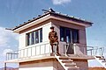
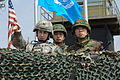 Republic of Korea (ROK) soldiers and a United States (U.S.) officer monitor the Korean Demilitarized Zone from atop OP Ouellette near Panmunjeom.
 -
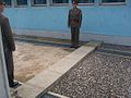
 An ROK soldier protects the door to North Korea in the building where the armistice was signed.
 -
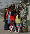 A U.S. soldier, assigned to the United Nations Command Security Battalion, meets local children.
 -
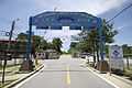
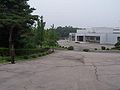
 Main entrance into the North Korean DMZ, north of Panmunjom. 37°57′54.23″N 126°38′46.59″E / 37.9650639°N 126.6462750°E
 -
 Looking back toward the same entrance. An anti-tank measure carries the slogan: "Reunification without outside interference".
 -
 North Korean propaganda that states: "Let us pass on the united country to the next generation!".
 -
 The KPA has prepared cement blocks ready to act as emergency roadblocks. 37°57′52.88″N 126°38′53.14″E / 37.9646889°N 126.6480944°E
 -
 House where the Armistice Agreement was signed ending the Korean War. 37°57′40″N 126°39′53″E / 37.961092°N 126.6647°E
 -
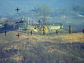 View from North Korea of an outpost on the southern boundary of the DMZ.


JSA
-
 The Republic of Korea's Freedom Building, JSA.
 -
 The original Freedom Pagoda.
 -
 Camp Bonifas stands just outside the South Korean Joint Security Area.
 -
 A Korean People's Army watchtower in the Joint Security Area in March 1976.
 -
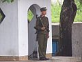 A DPRK soldier standing guard on the road to the JSA.
 -
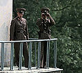 North Korean border troops monitor Conference Row.
 -
 North Korea's Hall of Unification in the JSA. 37°57′27.69″N 126°40′37.17″E / 37.9576917°N 126.6769917°E
 -
 The concrete boundary in Conference Row, JSA.
 -
 Crossing into the DPRK's part of Joint Security Area within the DMZ.
 -
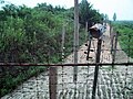
 Military Demarcation Line marker on the South Korean side of the Bridge of No Return.
 -
 Looking toward North Korea across the Bridge of No Return. 37°57′21.88″N 126°40′18.86″E / 37.9560778°N 126.6719056°E
 -
 ROK MP stands guard on the Bridge of No Return.


See also
Notes
- ^ "Korean Demilitarized Zone: Image of the Day". NASA Earth Observatory. Retrieved 2010-03-26.
- ^ Bermudez (2001), pg 1.
- ^ "Background Note: North Korea", US Department of State, October, 2006.
- ^ Elferink, Alex G. Oude. (1994). The Law of Maritime Boundary Delimitation: a Case Study of the Russian Federation, p. 314., p. 314, at Google Books
- ^ Potts, Rolf (3 February 1999). "Korea's no-man's-land". Salon. Retrieved 31 January 2013.
- ^ a b c "DMZ sixth-graders become graduates". Stars and Stripes. 2008-02-19.
{{cite news}}: Italic or bold markup not allowed in:|publisher=(help) - ^ "Santa mobbed by students during visit to Joint Security Area". army.mil.com -The Official U.S. Army Website. Retrieved 2009-12-11.
- ^ Kwaak, Jeyup S (24 September 2014). "Why the Korean Peninsula Keeps Land Mines". Wall Street Journal.
- ^ "Panmunjon". army.mil.com. Retrieved 2009-12-15. [dead link]
- ^ http://www.stripes.com/news/pacific/korea/general-revisits-deadly-1984-thanksgiving-firefight-at-dmz-1.161443
- ^ "Korea Demilitarized Zone Incidents". 2009-05-28.
- ^ "South Korea to revamp DMZ towers". Stars and Stripes. 2009-10-22. Retrieved 2009-11-09.
{{cite news}}: Italic or bold markup not allowed in:|publisher=(help) - ^ "North Korea: Chronology of Provocations, 1950 – 2003" (PDF). Retrieved 2012-02-02.
- ^ Bolger, Daniel (1991). Scenes from an Unfinished War: Low intensity conflict in Korea 1966–1969. Diane Publishing Co. ISBN 978-0-7881-1208-9.
- ^ "Scenes from an Unfinished War: Low-Intensity Conflict in Korea, 1966–1968" (PDF). Cgsc.leavenworth.army.mil. Retrieved 2012-02-02.
- ^ "KOREA: Careful Response to an Accident". TIME. 1977-07-25. Retrieved 2010-09-11.
- ^ a b c John Pike. "Demilitarized Zone". Globalsecurity.org. Retrieved 2010-09-11.
- ^ Park Soo Gil. "Letter dated 28 July 1997 from the permanent representative of the Republic of Korea to the United Nations addressed to the President of the Security Council". United Nations Archives and Records Management Section. 1997-07-28. Retrieved 2013-04-08.
- ^ "South Korean 'defector' wanted for assault". Associated Press. 2009-10-28. Retrieved 2015-05-08.
- ^ "North Korea [sic] troops 'fire into South Korea'". BBC News. 2010-10-29. Retrieved 2010-10-29.
- ^ "Military Admits Lies and Lapses Over Defection". The Chosun Ilbo. 11 October 2012.
- ^ "Defecting N.Korean Soldier 'Saw No Hope'". The Chosun Ilbo. 8 October 2012.
- ^ "Man Killed Trying to Defect to N.Korea". The Chosun Ilbo. 17 September 2013.
- ^ "Mystery drones found in Baengnyeong, Paju". JoongAng Daily. 2 April 2014. Retrieved 16 September 2014.
- ^ "South Korea: Drones 'confirmed as North Korean'". BBC News. 8 May 2014. Retrieved 16 September 2014.
- ^ http://news.yahoo.com/north-south-korea-exchange-gunfire-border-latest-clash-114559658.html;_ylt=AwrSyCWrpUVUghUAEpvQtDMD
- ^ "North Korea soldier walks over DMZ and defects". BBC World News - Asia. 15 June 2015. Retrieved 21 June 2015.
- ^ a b Choe Sang-hun (10 August 2015). "South Korea Accuses the North After Land Mines Maim Two Soldiers in DMZ". New York Times. Retrieved 13 August 2015.
- ^ Ju-min Park and Tony Munroe (20 August 2015). "North and South Korea exchange artillery fire". Reuters. Retrieved 20 August 2015.
- ^ "Minutes of Washington Special Actions Group Meeting, Washington, August 25, 1976, 10:30 a.m." Office of the Historian, U.S. Department of State. 25 August 1976. Retrieved 12 May 2012.
Clements: I like it. It doesn't have an overt character. I have been told that there have been 200 other such operations and that none of these have surfaced. Kissinger: It is different for us with the War Powers Act. I don't remember any such operations.
- ^ Lee Tae-hoon (7 February 2011). "S. Korea raided North with captured agents in 1967". The Korea Times. Retrieved 12 May 2012.
- ^ Sides, Jim (2009). Almost Home. Xulon Press. p. 118. ISBN 978-1-60791-740-3.
- ^ "Demilitarized Zone". GlobalSecurity.org. Retrieved 2007-11-09.
- ^ Bermudez, Joseph S. Jr. "Tunnels under the DMZ". korean-war.com. Archived from the original on 2013-06-21. Retrieved 2010-03-26.
- ^ Robinson, Martin (2009). Seoul. Lonely Planet. p. 162. ISBN 978-1-74104-774-5.
- ^ "The Fourth Infiltration Tunnel". Panmunjom Travel Center.
- ^ a b c Potts, Rolf (1999-02-03). "Korea's No-Man's-Land". Salon.
- ^ O'Neill, Tom. "Korea's DMZ: Dangerous Divide". National Geographic, July 2003.
- ^ Silpasornprasit, Susan. "Day trip to the DMZ: A look inside the Korean Demilitarized Zone". IMCOM-Korea Region Public Affairs Office, US Army. Retrieved 2009-01-30.
- ^ a b "Koreas switch off loudspeakers". BBC. 15 June 2004. Retrieved 7 May 2013.
- ^ PARK, JU-MIN (2015-08-10). "South Korea condemns North over land mine blast, vows retaliation". Reuters. Seoul: http://www.reuters.com/. Retrieved 2015-08-10.
{{cite news}}: External link in|publisher= - ^ http://www.nytimes.com/2015/08/21/world/asia/north-korea-and-south-korea-exchange-rocket-and-artillery-fire.html?_r=0
- ^ "South Korea turns off propaganda as Koreas reach deal". 2015-08-25. Retrieved 2015-08-25.
- ^ "Korea's DMZ: 'Scariest place on Earth'". CNN. 2002-02-20. Retrieved 2007-10-23.
- ^ 개성에 '구멍탄' 5만장 배달했습니다. economy.ohmynews.com (in Korean). Retrieved 2006-12-06.
- ^ AP (2011-09-08). "Tajikistan says it'll unfurl world's longest flag". Yahoo Daily News. Retrieved 3 October 2012.
- ^ "Welcome to North Korea: A film by Peter Tetteroo for KRO Television". Retrieved 2009-12-29.
- ^ "DMZ: Demilitarized Zone". Korea Konsult. Retrieved 16 April 2015.
{{cite web}}: Italic or bold markup not allowed in:|publisher=(help) - ^ "New York Times, 1999". Korean-war.com. Retrieved 2012-02-02.
- ^ "Tear Down the Korean Wall". DPRK UN Mission. 1999-12-03. Retrieved 2007-10-29.
{{cite news}}: Cite has empty unknown parameter:|coauthors=(help) - ^ "10 Days in North Korea". RT. 9 November 2014. Retrieved 9 May 2015.
- ^ Chang, Jae-Soon (2008-11-28). "Last train to Kaesong as Korean relations cool". Edinburgh: News.Scotman.Com.
- ^ "Inter-Korean economic cooperation Kaesong office reopens". Englishhani. 2009-09-07. Retrieved 2009-09-17.
- ^ "ROK woman tourist shot dead at DPRK resort". China Daily. 2008-07-12.
{{cite news}}: Italic or bold markup not allowed in:|publisher=(help) - ^ "N Korea steps up row with South". BBC. 2008-08-03.
- ^ "North Korea 'to seize property at Kumgang resort'". BBC. 2010-04-23.
- ^ a b c "Korea's DMZ: The thin green line". CNN. 2003-08-22. Retrieved 2009-07-30.
- ^ "Korean 'Tigerman' Prowls the DMZ". International Korean News. Retrieved 2009-07-17.
- ^ "Ted Turner: Turn Korean DMZ into peace park". USA TODAY. 2005-11-18. Retrieved 2010-05-07.
- ^ Choi, Chungil. "Nomination of Korea DMZ Biosphere Reserve" (PDF). Retrieved 3 October 2012.
- ^ Kim, Jeong-su. "Seoul to seek UNESCO Biosphere Reserve status for DMZ". Hankyoreh. Retrieved 3 October 2012.
- ^ Cho, Do-soon (Aug 14, 2012). "Biosphere reserve status for the DMZ is urgent". JoonAng Daily. Retrieved 3 October 2012.
References
- Bermudez, Joseph S. (2001). Shield of the Great Leader. The Armed Forces of North Korea. The Armed Forces of Asia. Sydney: Allen & Unwin. ISBN 1-86448-582-5.
{{cite book}}: Cite has empty unknown parameter:|coauthors=(help) - Elferink, Alex G. Oude, (1994). The Law of Maritime Boundary Delimitation: a Case Study of the Russian Federation. Dordrecht: Martinus Nijhoff. ISBN 9780792330820; OCLC 123566768
- CNN World News (2015) "South Korea warns North will pay 'harsh price' over DMZ landmine blasts" http://www.cnn.com/2015/08/09/asia/koreas-tensions/
External links
- U.S. Army official Korean Demilitarized Zone image archive
- Washington Post Correspondent Amar Bakshi travels to the Korean Demilitarized Zone... And uncovers the world's most dangerous tourist trap, January 2008.
- Status and ecological resource value of the Republic of Korea's De-militarized Zone
- Tour Of DMZ on YouTube. Dec. 2007
- DMZ Forum: Collaborative international NGO focusing on promoting peace and conservation within the Korean DMZ region
- ABCNews/Yahoo! report/blog on the DMZ
- North Korea places Mines on the Southern Half of the DMZ