Kumlinge Airfield
Appearance
Kumlinge Airfield Kumlinge flygfält Kumlingen lentokenttä | |||||||||||
|---|---|---|---|---|---|---|---|---|---|---|---|
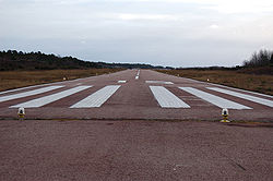
 Runway of Kumlinge Airfield | |||||||||||
| Summary | |||||||||||
| Operator | Government of Åland | ||||||||||
| Location | Kumlinge, Åland, Finland | ||||||||||
| Elevation AMSL | 7 ft / 2 m | ||||||||||
| Coordinates | 60°14′49″N 020°48′17″E / 60.24694°N 20.80472°E | ||||||||||
| Map | |||||||||||
 | |||||||||||
| Runways | |||||||||||
| |||||||||||
Source: VFR Finland[1] | |||||||||||
Kumlinge Airfield (ICAO: EFKG) (Template:Lang-sv, Template:Lang-fi) is an airfield in Kumlinge, Åland, Finland.[1]
The airfield was opened in 1975,[2] and it is operated by the Government of Åland.[1]
See also
References
- ^ a b c "Kumlinge, Finland – EFKG". VFR Suomi / Finland. Vantaa: Finavia. 18 November 2010. Archived from the original on 16 October 2007. Retrieved 11 August 2011.
{{cite web}}: Unknown parameter|deadurl=ignored (|url-status=suggested) (help) - ^ "Kumlinge". Upplagsverket Finland (in Swedish). Schildts Förlags Ab. Archived from the original on 16 March 2012. Retrieved 11 August 2011.
{{cite web}}: Unknown parameter|deadurl=ignored (|url-status=suggested) (help)
External links
![]() Media related to Kumlinge Airfield at Wikimedia Commons
Media related to Kumlinge Airfield at Wikimedia Commons

