Liternum
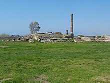
 Ruins of Liternum, Lago Patria | |
| Location | Giugliano in Campania, Province of Naples, Italy |
|---|---|
| Region | Campania |
| Type | Settlement |
| Site notes | |
| Management | Soprintendenza per i Beni Archeologici di Napoli |
| Public access | Yes |
| Website | Sito Archeologico di Liternum Template:It icon |
Liternum was an ancient town of Campania, Italy, on the low sandy coast between Cumae and the mouth of the Volturnus. It was probably once dependent on Cumae. In 194 BC it became a Roman colony. Although Livy records that the town was unsuccessful,[1] excavation reveals a Roman town existed there until the 4th century AD.[2]
The town is mainly famous as the residence of the elder Scipio Africanus, who withdrew from Rome and died there. His tomb and villa are described by Seneca the Younger.[3][4] In Ovid's Metamorphoses Liternum is mentioned for its mastic trees: lentisciferum... Liternum.[5] Augustus Caesar is said to have conducted a colony of veterans to Liternum. However, the place never had any great importance, and the lagoons behind it made it unhealthy. The construction of the Via Domitiana through Liternum made it a posting station, but the town later had a malaria outbreak and went into decline.[2]
References
External links
- The Hunterian Museum's page on Liternum, with maps and photos.
- This article incorporates text from a publication now in the public domain: Chisholm, Hugh, ed. (1911). Encyclopædia Britannica (11th ed.). Cambridge University Press.
{{cite encyclopedia}}: Missing or empty|title=(help)


