
Llanquihue Lake
This article needs additional citations for verification. (April 2008) |
| Lake Llanquihue | |
|---|---|
 The lake as seen from Osorno volcano with Calbuco visible on the left | |
| Coordinates | 41°08′S 72°47′W / 41.133°S 72.783°W |
| Primary outflows | Maullín River |
| Basin countries | Chile |
| Surface area | 860 km2 (330 sq mi) |
| Max. depth | 317 m (1,040 ft) |
| Surface elevation | 70 m (230 ft) |
| Settlements | Puerto Varas, Llanquihue, Frutillar, Puerto Octay |
Lake Llanquihue is the second largest lake in Chile with an area of about 860 square kilometres (330 sq mi). It is situated in the southern Los Lagos Region in the Llanquihue and Osorno provinces. The lake's fan-like form was created by successive piedmont glaciers during the Quaternary glaciations. The last glacial period is called Llanquihue glaciation in Chile after the terminal moraine systems around the lake.[1]
Lake Llanquihue is located in southern Chile a territory of northern Patagonia in the Los Lagos Region. The lake's views of Volcán Osorno make the surrounding cities such as Puerto Varas tourism hotspots.
Gallery
-
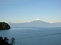 A view of the Osorno volcano from across the lake

References
- ^ Patagonia Chilena ISBN 978-956-310-774-6 [page needed]
External links
 Media related to Lake Llanquihue at Wikimedia Commons
 Geographic data related to Llanquihue Lake at OpenStreetMap