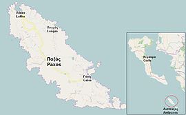
Longos, Paxoi
Appearance

Longos
Λογγός | |
|---|---|
Settlement | |
 Longos on the map. | |
| Coordinates: 39°13.5′N 20°9.6′E / 39.2250°N 20.1600°E | |
| Country | Greece |
| Administrative region | Ionian Islands |
| Regional unit | Corfu |
| Municipality | Paxoi |
| Population (2011)[1] | |
| • Rural | 81 |
| • Community | 298 |
| Time zone | UTC+2 (EET) |
| • Summer (DST) | UTC+3 (EEST) |
Longos (Greek: Λογγός) is the smallest of the island ports on Paxoi, one of the Ionian Islands of Greece. At the 2011 census, its population was 81 for the village and 298 for the municipal district, which includes the villages Anemogiannatika, Dendiatika, Kagkatika, Kontogiannatika and Koutsi.
Population
| Year | Settlement population | Population municipal district |
|---|---|---|
| 1981 | - | 275 |
| 1991 | 62 | - |
| 2001 | 71 | 280 |
| 2011 | 81 | 298 |
Geography
Longos is situated on the northeast coast of the island, and has a small fishing harbour. There are several shops and bars. At one end of Longos harbour stands the tall chimney from an abandoned soap factory. There are several shingle beaches nearby.
See also
External links
References
- ^ "Απογραφή Πληθυσμού - Κατοικιών 2011. ΜΟΝΙΜΟΣ Πληθυσμός" (in Greek). Hellenic Statistical Authority.

