
Märket


Märket (IPA: [ˈmærkə(t)], Swedish for "The Mark") is a small uninhabited skerry in the Baltic Sea between Sweden and Finland (in the area of the autonomous Åland Islands), that since the Treaty of Fredrikshamn (Hamina) of 1809 defined the border between Sweden and Russian empire of going straight through the island. The westernmost land point of Finland is on Märket.
Geography and history
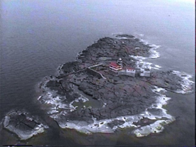
The 6 nautical mile (11 km) wide Understen–Märket Passage links the Bothnian Sea to the Baltic proper. The area of the skerry, which measures roughly 350 m (1150 ft) long by 150 m (490 ft) wide, is said to be 3 hectares (30,000 m² or 320,000 sq ft) which is argued to make it the smallest "sea island" shared by two countries.[1]
There is a lighthouse on the Finnish side of the island, which has been unmanned and automated since 1979. When it was built in 1885 there were no clear maps of the island. After the completion of the lighthouse, it was discovered that it had been built on the Swedish part of the island.

As a result, the border was adjusted in 1985 so that the lighthouse is now located on Finnish territory.[2] However, the overall land area given to each country could not change, and neither could the coastline, so as not to interfere with each country's fishing rights.
This dilemma resulted in an unusual shape for the international border, one that ingeniously satisfied both Finnish and Swedish interests. Since the adjustment of the border, it takes the form of an inverted 'S', the lighthouse only connected to the rest of Finland by a short stretch of land. The border is regularly resurveyed every 25 years by officials representing both countries. The last such joint inspection took place in August 2006.[3]
The lighthouse is in urgent need of maintenance, and a Finnish interest group is trying to raise funds for its preservation. The lighthouse has been automatic since 1976 and the surrounding buildings are no longer used.
Radio activity
Market Reef, as it is called in English among three million radio amateurs around the world, is a "separate country". Market Reef is one of the world's most wanted "countries" among radio amateurs due to its special status and inaccessibility. Usually there are one or more amateur radio expeditions to the island every year, weather permitting. During these expeditions tens of thousands of radio contacts are made with the entire world. At high seas, landing is only possible with a helicopter. Probably the best picture available over Märket is shown on a QSL card, a verification card sent out to verify a radio contact among radio amateurs. OJ0 is the call sign prefix for Market Reef. All radio activity on the island is by visitors on DX-peditions. The most recent trip to the island took place in September 2007 by Martti Laine (OH2BH), Pertti Simovaara (OH2PM), Ville Hiilesmaa (OH2MM), Antti Nevantaus (OH7EA), Juha (OH8NC) and Lars Nikko (OHØRJ). "Märkets Fyr" means Märket's Lighthouse in Swedish.[4]
See also
References
- ^ World island superlatives
- ^ Märket - a remarkable island by Joakim Ekman, Lars-Gunnar Bråvander, Gabriel Ekmand, and Ebbe Zachrisson Template:Sv icon includes a map of the island
- ^ Shifting Territories: Märket Reef, Hidden Europe Magazine, 11 (November 2006), pp.26-29.
- ^ Radio Am Amateur radio site
External links
- 2007 Radio DXpedition to Märket
- Configurable map centred on Märket from Citizen's Mapsite of Finland
- The Swedish Lighthouse Society's site on Märket
- Joint border survey between Finland and Sweden in progress from Helsingin Sanomat (International Edition), includes paragraph about Märket, with a small map.
- A recent air photography over the entire island