Măgurele
Appearance
Măgurele | |
|---|---|
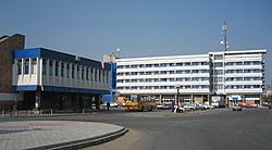
 Downtown Măgurele, 2007 | |
| Coordinates: 44°23′41″N 26°3′58″E / 44.39472°N 26.06611°E | |
| Country | |
| County | Ilfov County |
| Population (2002)[1] | 9,272 |
| Time zone | UTC+2 (EET) |
| • Summer (DST) | UTC+3 (EEST) |
| Website | http://www.primariamagurele.ro |
Măgurele is a town situated in the southwestern part of Ilfov County, Romania. Its population is 9,200. Four villages are administered by the town: Alunișu, Dumitrana, Pruni and Vârteju.
The town hosts a nuclear research lab, the Institute of Atomic Physics (Romanian: Institutul de Fizicǎ Atomicǎ (IFA)) and its National Institute for Physics and Nuclear Engineering. Between 1957 and 1998, it had a Soviet VVRS research reactor, now closed down. The Faculty of Physics of the University of Bucharest is also located in Măgurele.

History
| Year | Pop. | ±% |
|---|---|---|
| 2002 | 9,200 | — |
| 2011 | 10,565 | +14.8% |
| Source: Census data | ||
Its name is derived from a Romanian word possibly of Dacian origin, măgură, meaning "hill".
References
- ^ Romanian census data, 2002 Retrieved on April 5, 2016.
External links
Wikimedia Commons has media related to Măgurele.


