SS Lake Illawarra
| History | |
|---|---|
| Name | SS Lake Illawarra |
| Operator | Australian Coastal Shipping Commission (later renamed Australian National Line) |
| Builder | BHP at Whyalla, South Australia[citation needed] |
| Launched | 1958[citation needed] |
| Out of service | 1975 |
| Fate | Sank after colliding with Tasman Bridge, Hobart on 5 January 1975 |
| General characteristics | |
| Type | Steel bulk ore carrier |
| Tonnage | 7,273.75 gross tons, 4,342.97 net tons[citation needed] |
| Length | 446.15 feet (135.99 m)[citation needed] |
| Beam | 58.75 feet (17.91 m)[citation needed] |
| Draught | 31.4 feet (9.6 m)[citation needed] |
| Installed power | Oil-fired boilers, built by John Kempson (Australia) Pty. Ltd.[citation needed] |
| Propulsion | two Parsons-type steam turbines built by Cockatoo Dock and Engineering Co., Pty. Ltd., Sydney. Single-shaft.[citation needed] |
| Speed | 12 knots (22 km/h; 14 mph)[citation needed] |
| Crew | 42[citation needed] |
MV Lake Illawarra was a handysize bulk carrier of 7,274 tons in the service of the Australian National Line shipping company. This ship is known for causing the Tasman Bridge disaster when it collided with pylon 19 of Hobart's giant high concrete arch style Tasman Bridge on the evening of 5 January 1975 at 9.27 p.m.,[1][2][3] causing the deaths of 12 people.
Collision and sinking
Lake Illawarra was loaded with zinc concentrate, for the Electrolytic Zinc Company (more recently known as Zinifex and OZ Minerals) refinery (now run by Nyrstar) at Risdon, about 3 nautical miles (5.6 km; 3.5 mi) up the River Derwent from the bridge.[2]
Just before the impact, Captain Boleslaw Pelc realised as he passed Rosny Point that he was off course, and traveling too fast. He tried to correct the heading, but only managed to bring the bows too far to port (left) and was now heading for the western shore. He urgently counter-corrected, but could not make the opening. Realising he was headed for a collision, he put the engines full astern, but the torque from her propeller caused the ship to slide in a broadside movement. She smashed into the 18th and 19th pylons.[1]

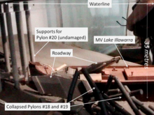
The collision brought down the two support pylons and a 127-metre (417 ft) section of steel and concrete.[3] There was evening traffic on the bridge, and although no vehicles were on the section that fell, four cars drove off the gap, with five people killed.[3] Two cars stopped on the edge, their occupants able to escape.[3] The section of four-lane highway landed on the ship's deck, sinking her in 35 metres (115 ft) of water to the south of the bridge. Seven of the ship's crew lost their lives in the accident.[1][3]
The ship and the debris pile were deemed unsafe to move; the ship's oil was pumped out, and the bow was removed at a later date.[1] The wreck is deep enough not to be a navigational hazard,[4] although movement caused by tides is considered enough of a threat to the bridge to be monitored closely by electronic sensors.[citation needed]
The subsequent Court of Marine Inquiry found that Lake Illawarra was capable of passing beneath the bridge's central navigation span, but the captain instead attempted to pass through one of the eastern spans, due to a combination of strong tidal currents and inattention.[1][5] The Court found that Pelc had not handled Lake Illawarra in a proper and seamanlike manner, and suspended his master's certificate for six months.[1] A pilot service was introduced in response to the Court's findings.[5]
References
- ^ a b c d e f "Shipwrecks of Tasmania". Retrieved 20 August 2007.
- ^ a b "Feature Article - The Tasman bridge". 1301.6 - Tasmanian Year Book, 2000. Australian Bureau of Statistics. 13 September 2002. Retrieved 4 April 2007.
- ^ a b c d e "Tasman Bridge disaster". Clarence City Council. Retrieved 20 August 2007.
- ^ Steven Dally (8 December 1995). "SAFE For another 70 years". The Mercury. Retrieved 4 April 2007.
- ^ a b "Hobart, Tas: Bridge Collapse". Attorney General's Department-Emergency Management Australia. Retrieved 20 August 2007.
