MacArthur Tunnel
Appearance
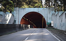
 West entrance of the MacArthur Tunnel | |
| Overview | |
|---|---|
| Other name(s) | General Douglas MacArthur Tunnel |
| Location | San Francisco, California |
| Route | |

The MacArthur Tunnel, formally known as the General Douglas MacArthur Tunnel, is a highway tunnel in San Francisco, California.
It is located within the Presidio of San Francisco, now part of the Golden Gate National Recreation Area.
The tunnel carries California State Route 1 under a large hill and under the Presidio Golf Course. It connects Park Presidio Boulevard (Hwy 1) in the Richmond District to US 101 on the Doyle Drive viaduct, and the Golden Gate Bridge.
37°47′33.7″N 122°28′10.48″W / 37.792694°N 122.4695778°W
