
Mahé, Seychelles
 Mahé | |
| Geography | |
|---|---|
| Location | Seychelles, Indian Ocean |
| Coordinates | 4°40′S 55°28′E / 4.667°S 55.467°E |
| Archipelago | Inner Islands, Seychelles |
| Adjacent to | Indian Ocean |
| Administration | |
Seychelles | |
| Demographics | |
| Population | 95,000 |
| Additional information | |
| Time zone | |
| Official website | www |
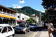
Mahé is the largest island (157.3 km²) of Seychelles, lying in the northeast of the nation in the Indian Ocean. The population of Mahé was 77,000, as of the 2010 census.[1] It contains the capital city of Victoria and accommodates 86% of the country's total population. The island was named after Bertrand-François Mahé de La Bourdonnais, a French governor of Isle de France (modern-day Mauritius).
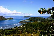
Mahé's tallest peak is Morne Seychellois at 905 m (2,969 ft), which lies in the Morne Seychellois National Park. The northern and eastern parts of the island are home to much of the population and the Seychelles International Airport which opened in 1971. The southern and western parts have Baie Ternay Marine National Park, Port Launay Marine National Park, and University of Seychelles. The Sainte Anne Marine National Park lies offshore, as do Conception Island, Thérèse Island, Anonyme Island and several smaller islands.
Mahé was first visited by the British in 1609 and not visited by Europeans again until Lazare Picault's expedition of 1742. The French navy frégate Le Cerf (English: The Deer) arrived at Port Victoria on 1 November 1756. On board was Corneille Nicholas Morphey, leader of the French expedition, which claimed the island for the King of France by laying a Stone of Possession on Mahe, Seychelles’ oldest monument, now on display in the National Museum, Victoria.
In August 1801 a Royal Navy frigate HMS Sibylle captured the French frigate Chiffonne on the island. Mahé remained a French possession until 1812 when it became a British colony. It remained a colony until 1976 when Seychelles became an independent nation.
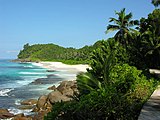
Mahé's forests have rare endemic plants found only in Seychelles, such as the critically endangered Medusagyne oppositifolia (the jellyfish tree), the carnivorous Nepenthes pervillei (Seychelles pitcher plant), and many unique species of orchid.
Mahé had a huge land reclamation project due to a shortage of housing, in the areas of Bel Ombre and the Port of Victoria.[2]
Economy
Mahé's economy is mainly dependent on tourism. Air Seychelles has its head office on the property of Seychelles International Airport on the island.[3] The Port of Victoria is home to a tuna fishing and canning industry.
Administration
The island has multiple districts.[4]
Gallery
-
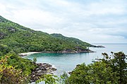 View point Anse Major, Mahe
 -
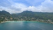 Aerial of Beau Vallon Mahe, Seychelles
 -
 Beach resort Mahe Island, Seychelles
 -
 Eden island Mahe
 -
 View point at Anse Intendance beach, Mahe
 -
 Aerial of beach Anse Intendance
 -
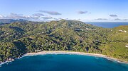
 Aerial of Anse Takamaka beach, Mahe
 -
 Map 1
Map 1 -
 Mahé's capital Victoria
 -
 Mahé's capital Victoria
 -
 Mahé
Mahé -
 Beach
Beach -
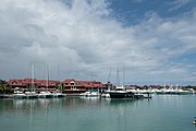
 Mahé's Harbour
 -
 Port Launay Beach, Mahé
.jpg)
.jpg)
.jpg)
.jpg)
.jpg)
.jpg)
.jpg)

.jpg)


References
- ^ "Population and Housing Census 2010 Report" (PDF). National Bureau of Statistics. p. 8. Archived from the original (PDF) on 14 May 2014. Retrieved 12 November 2013.
{{cite web}}: Unknown parameter|deadurl=ignored (|url-status=suggested) (help) - ^ New plan
- ^ "Offices & GSAs head Office Archived 7 July 2011 at the Wayback Machine." Air Seychelles. Retrieved on 29 January 2011 "Head Office Air Seychelles Ltd Head Office International Airport P.O.Box 386 Victoria, Mahé, Seychelles."
- ^ District map